NHPC Blog
NHPC Awarded CBIP Award for Best Performing Utility in Hydropower Sector
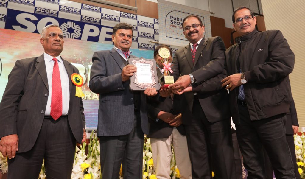
NHPC Limited, India’s premier hydropower company was awarded “CBIP Award for Best Performing Utility in Hydropower Sector” at CBIP Awards on CBIP Day on 04 January 2019 in New Delhi. The award was given for outstanding contribution to the nation for development and efficient operation of Hydropower Plants in the country besides contribution for development of Hydropower in the neighboring countries.
Shri Balraj Joshi, CMD, NHPC & Shri Janardan Choudhary, Director (Technical), NHPC received the award on behalf of NHPC from Shri R.K. Singh, Hon’ble Union Minister of State (I/C) for Power and New & Renewable energy. Shri Devineni Uma Maheshwara Rao, Hon’ble Minister of Water Resources, Government of Andhra Pradesh; Shri A. K. Bhalla, Secretary, Ministry of Power; Shri U.P. Singh , Secretary, Ministry of Water Resources, River Development & Ganga Rejuvenation; Shri S. Masood Husain, President, CBIP & Chairman, Central Water Commission and Shri V.K. Kanjlia, Secretary, CBIP were also present on the occasion.
The CBIP Awards recognize outstanding contributions by organizations and individuals involved in formulation of policies and programmes and their implementation, research & development, design, execution, management, operation & maintenance, renovation & modernization, manufacturing of equipment and capacity building in furthering the cause of Water Resources, Power and Renewable Energy Sectors in the country.
पर्यावरण वार्ता (अंक 1)
एनएचपीसी द्वारा पर्यावरण के क्षेत्र में सतत और सकारात्मक कार्य किए जा रहे हैं। परियोजनाओं/ पावर स्टेशनों/ क्षेत्रीय कार्यालयों एवं निगम मुख्यालय मे पर्यावरण संवर्धन के दृष्टिगत अनेक प्रयास किये जाते हैं, इन सभी का समुचित दस्तावेजीकरण ही नहीं अपितु उनके प्रसार की भी आवश्यकता है। इसी तथ्य को ध्यान मे रख कर पर्यावरण एवं विविधता प्रबंधन विभाग द्वारा ब्लॉग (ई-पत्रिका) का आरंभ किया गया है। इस माध्यम से पर्यावरण संवर्धन के कार्यों, वरिष्ठ अधिकारियों द्वारा पर्यावरण विषय पर दिए गए संभाषणों/ प्रस्तुतिकरणों/ दिशानिर्देशों, तकनीकी आलेखों, पर्यावरण समाचारों, पर्यावरण संबंधी वैश्विक उल्लेखनीय जानकारियों, सम्बंधित ऑडियो-विडियो, सुझावों आदि का प्रस्तुतिकरण किया जाना है।
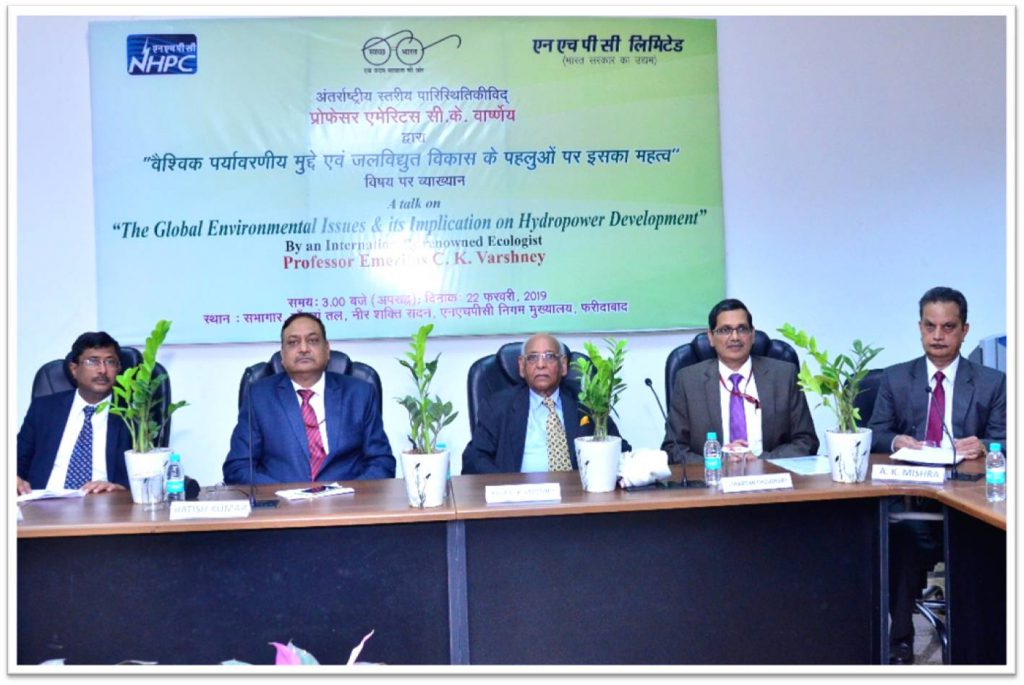
इसी कड़ी में यह सूचित करना प्रासंगिक होगा कि दिनांक 22.02.2019 को “वैश्विक पर्यावरणीय मुद्दे एवं जलविद्युत विकास के पहलुओं पर इसका महत्व” विषय पर निगम मुख्यालय में कार्यरत वरिष्ठ अधिकारियों के लिए व्याख्यान का आयोजन किया गया । इस कार्यक्रम का उद्देश्य पर्यावरण नीति के कुशल अनुपालन एवं कार्यान्वयन हेतु आंतरिक हितधारकों को संवेदनशील एवं जागरूक बनाना था। इस महत्व के विषय पर व्याखान देने के लिए प्रख्यात पर्यावरणविद प्रोफेसर सी. के. वार्शने, जवाहरलाल नेहरू विश्वविद्यालय, नई दिल्ली को आमंत्रित किया गया था। ब्लॉग पर उनके व्याख्यान का सार-संक्षेप प्रस्तुत किया जा रहा है।
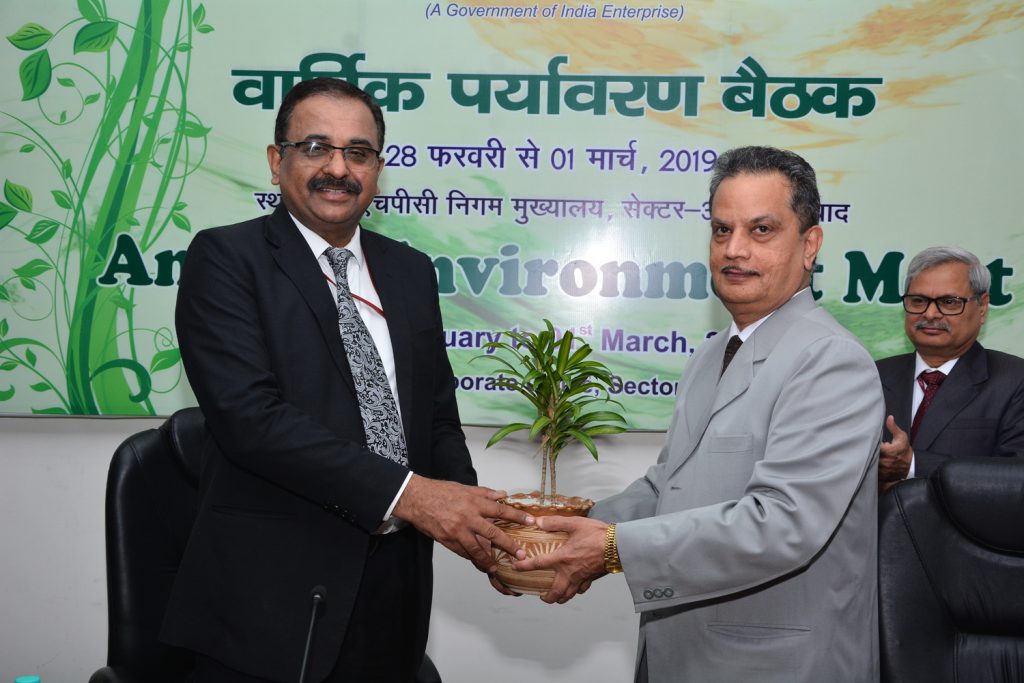
निगम मुख्यालय मे दिनांक 28 फरवरी एवं 1 मार्च को वार्षिक पर्यावरण सम्मेलन 2018-19 का आयोजन किया जा रहा है। इस सम्मेलन में एनएचपीसी के अतिरिक्त एनएचडीसी तथा सीवीपीपी के पर्यावरण अधिकारी सम्मिलित होंगे। दो दिवसीय आयोजन मे अनेक महत्वपूर्ण विषय जिनमे – “Disaster Impact Assessment in Hydropower Projects”, “Policy Framework and Post Construction Monitoring in Hydropower Projects”, “Sustainable Development Goals and Their Significance in Hydropower Projects”, “Use of Geo-informatics in Environmental Management and Social Impact Assessment in Hydropower Projects”, “Forest clearance related issues in development of Hydropower Projects including FRA”, “Climate Change- Challenges and Opportunity in Hydropower Sector” आदि पर चर्चा के अतिरिक्त सभी परियोजनाओं/ पावरस्टेशनों से आये अधिकारी अपने कार्यानुभव साझा करेंगे। ब्लॉग के अगले अंक मे इस आयोजन पर विशेष सामग्री का प्रकाशन किया जायेगा।
ब्लॉग (ई-पत्रिका) एक सार्वजनिक मंच है जो न केवल निगम की पर्यावरण नीति, पर्यावरण से संबद्ध कार्यों आदि का प्रस्तुतिकरण करेगा अपितु सकारात्मक विमर्श को भी यहाँ देखा-पढ़ा जा सकेगा। इस उद्देश्य को सामने रखते हुए ई-पत्रिका का प्रथमांक प्रस्तुत है।
- अरुण कुमार मिश्रा
- कार्यपालक निदेशक
- पर्यारण एवं विविधता प्रबंधन विभाग
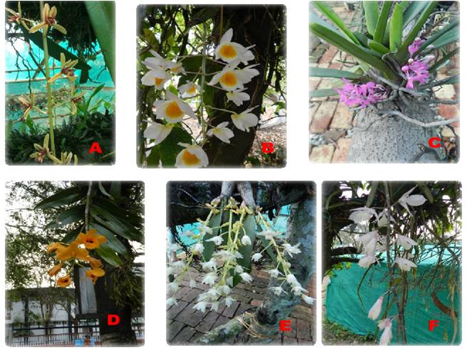
(चित्र -ओर्किडेरियम, तीस्ता लो डैम, चरण IV से। विवरण – A. Cymbidium aloifolium B. Dendrobium crepidatum C. Ascocentrum ampullaceum D. Dendrobium chrysanthum E. Dendrobium crepidatum F. Dendrobium aphyllum)
“The Global Environmental Issues and its Implications on Hydropower Development” held on 22nd Feb. 2019 at NHPC’s Corporate Office
A talk on “The Global Environmental Issues & its Implication on Hydropower Development” was delivered by Prof. C. K. Varshney, Professor Emeritus Jawaharlal Nehru University, New Delhi and a renowned ecologist. The aim of the talk was to sensitize and to educate the internal stakeholders of the company for efficient compliances and implementation of NHPC’s Corporate Environment Policy.
The talk was chaired by Shri Ratish Kumar, Director (Projects) in presence of Shri N.K. Jain, Director (Personnel) and Shri Janardan Choudhary, Director (Technical). Director (Projects) inaugurated the session by welcoming Prof. Varshney with plant and shawl. It was followed by welcoming of the Directors by presenting them plant by Shri A. K. Mishra, ED (E&DM).
Director (Projects) in his address appreciated the presence of senior officers for such an important talk. Director (Personnel) also expressed his happiness about organizing this kind of talk for senior officers. Director (Technical) lauded the efforts of EDM Division in organizing such talk and expressed that effort for development of clean and green energy in true sense has to come from everyone involved. ED(E&DM) in his welcome address appraised about the various voluntary initiatives taken/ being taken by the EDM Division.
Prof. Varshney gave a detailed talk on the Global Environmental Issues like Global Warming, Climate Change, Pollution, Deforestation and loss of soil, Species extinction including status of biodiversity in India, Water crisis and Overpopulation. He deliberated on significant implications of above environmental issues on the development of hydro-projects, focusing mainly on the different types of risks associated with the Climate Change, deforestation and Life-cycle emissions from hydroprojects vis-à-vis different electricity generating sources. He highlighted about a recent publication in scientific journal Nature which has indicated that the average Carbon Emissions from hydro-projects are significantly low in comparison to other conventional sources of energy over their working lives and it is lower than even Gas or Solar Photovoltaic based plants. Prof. Varshney concluded that risks associated with climate change are now real and they need to be identified, evaluated and integrated into design of the project for achieving the full life cycle of the project. He also emphasized that in order to find out the solution to the imminent problem it is important to appreciate the fact that there is a problem and he hoped that this talk would be able to help the planners in that direction. The talk was ended with vote of thanks proposed by Dr. Anil K. Tripathi, General Manager (Environment).
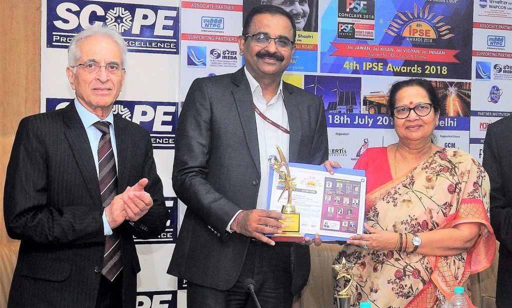
CMD, NHPC conferred IPSE Trophy
Shri Balraj Joshi, Chairman & Managing Director receiving the IPSE trophy for ‘Leadership in PSE’ at the 4th IPSE Awards 2018- India Public Sector Enterprises Awards for Excellence
Shri Balraj Joshi, Chairman & Managing Director, NHPC Limited, India’s premier hydropower company and a ‘Mini Ratna’ Category-I Enterprise of the Government of India has been awarded as ‘Winner’ of IPSE Trophy for ‘Leadership in PSE’ at the 4th IPSE Awards 2018- India Public Sector Enterprises Awards for Excellence held at New Delhi on 18th July 2018. Shri Joshi received the award from noted activist Smt. Neera Shastri. Shri Joshi has been given this prestigious award for his outstanding contribution to NHPC and to the cause of Hydro power sector at large. During his distinguished career spanning over 35 years, Shri Joshi has contributed to NHPC’s development by serving many projects namely Salal, Dul Hasti, Kurichu Project (Bhutan), Teesta-V, Teesta Low Dam-III & IV, Parbati-III, Chutak, Chamera-III, Parbati-II etc. He has also been associated with NHPC’s Consultancy assignments for many projects as 1200 MW Tamanthi and 880 MW Shwezaye in Myanmar, 720 MW Mangdechhu, Bhutan & Bakreswar Thermal Power Project of M/s West Bengal Development Corporation etc.
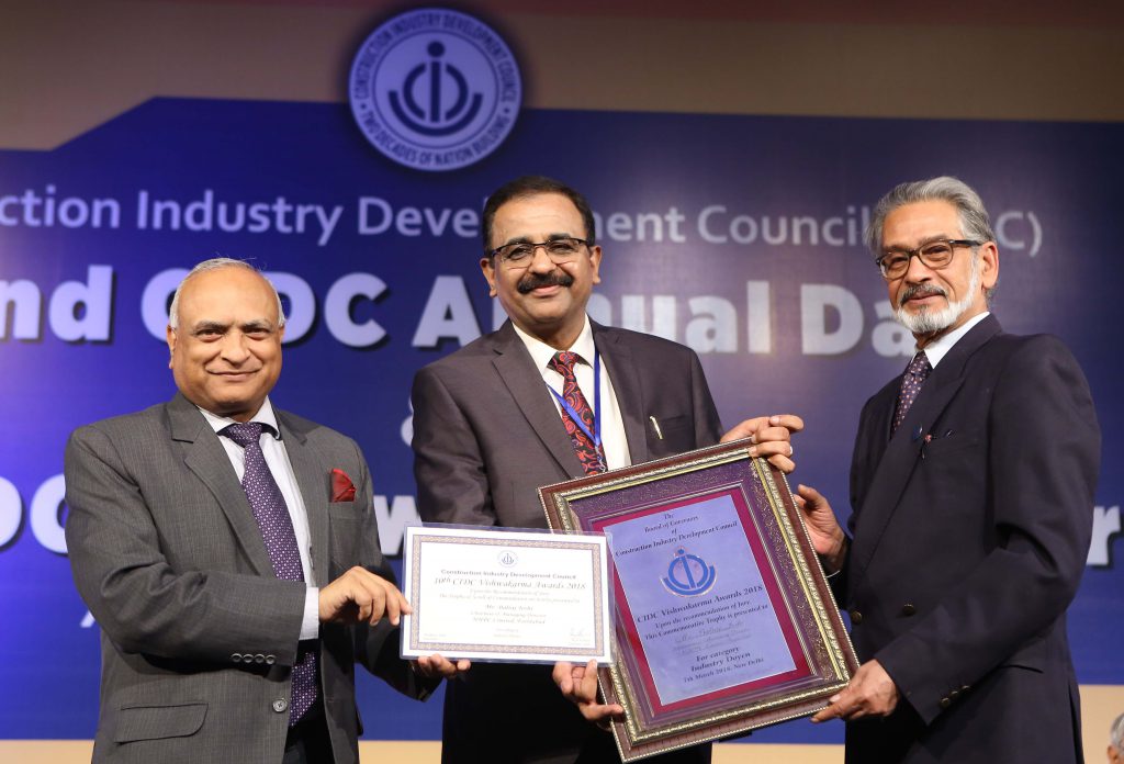
CMD, NHPC conferred ‘Industry Doyen’ award
Shri Balraj Joshi, CMD, NHPC Limited, India’s premier hydropower company has been conferred the ‘Industry Doyen’ award by Construction Industry Development Council at 10th CIDC Vishwakarma Awards held at India Habitat Centre, New Delhi on 7th March 2018. The award recognizes the significant contribution made by Shri Balraj Joshi in the field of hydropower development in the country as a leading professional with excellent project execution capabilities.
प्रोफेसर वार्शने के साथ एक तस्वीर
दिनांक 22.02.2019 को “वैश्विक पर्यावरणीय मुद्दे एवं जलविद्युत विकास के पहलुओं पर इसका महत्व” विषय पर निगम मुख्यालय में कार्यरत वरिष्ठ अधिकारियों के लिए प्रोफेसर सी. के. वार्शने, जवाहरलाल नेहरू विश्वविद्यालय, नई दिल्ली का व्याख्यान का आयोजन किया गया था। व्याख्यान के पश्चात प्रोफेसर वार्शने के साथ श्री जनार्दन चौधरी, निदेशक तकनीकी; श्री अरुण कुमार मिश्रा, कार्यपालक निदेशक (पर्यावरण एवं विविधता प्रबंधन), डॉ. अनिल कुमार त्रिपाठी, महाप्रबंधक (पर्यावरण) सहित पर्यावरण एवं विविधता प्रबंधन विभाग के निगम मुख्यालय मे कार्यरत सभी अधिकारियों ने समूह चित्र लिया।
Evaluating Effectiveness of Execution of Catchment Area Treatment Plan of Rangit Power Station (Sikkim), India using Remote Sensing and GIS Technology
Authors: Dr. Anil K Tripathi, GM (Env); Gaurav Kumar, DGM (Env); Rajeev Ranjan Prasad, SM (Env)
INTRODUCTION
The use of satellite remote sensing coupled with GIS has been recognized as an effective tool for formulation as well as temporal monitoring of catchments of various watersheds. The Remote Sensing Systems offer four basic components to measure and record data about an area from a distance viz. the energy source (electromagnetic energy), the transmission path, the target and the satellite sensor. As such, multi-spectral satellite remote sensing data with its synoptic and multi-temporal capability provides spatial information on forest cover, geology, hydrogeology, soils and landuse pattern to effectively characterize and monitor catchment properties.
Sedimentation in the reservoir is a function of soil erosion rate of the river catchment area. It reduces the water storage capacity of reservoir and availability of water for its designated use. A useful life of any hydroelectric project is directly related to the soil erosion rates of the catchment area. Therefore, the Catchment Area Treatment (CAT) plan pertains to preparation of a management plan for treatment of erosion prone area of the catchment through biological and engineering measures. Integrated watershed management aimed at minimizing the sedimentation of reservoir and ecosystem conservation are also prime objectives of the catchment area treatment.
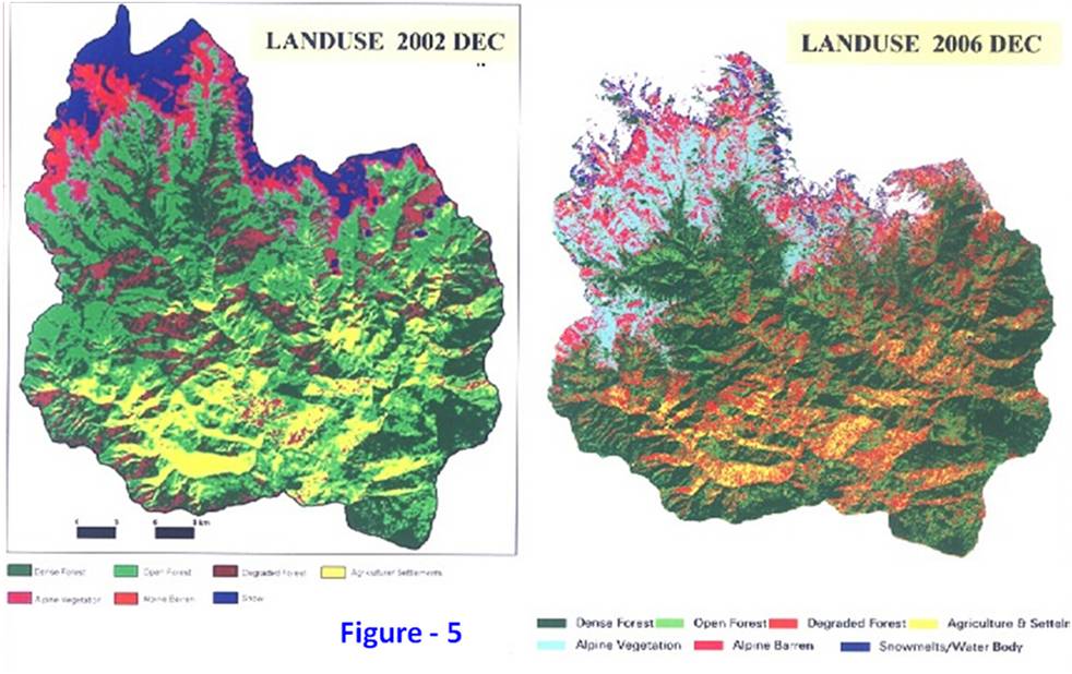
The present study was done in-house by Corporate Environment & Diversity Management Division, with the major objective to determine whether the proposed Catchment Area Treatment (CAT) Plan at Rangit Power Station has served its intended function. This Remote Sensing and GIS based study also provided a feed back regarding the effectiveness of recommended/implemented measures under catchment area treatment. The Catchment area treatment work was taken up in phased manner (year wise) starting from 1995-96 and completed in 2002-03. To assess the pre project scenario the November 1994 satellite data of IRS-1B LISS-II was used and further CAT status was evaluated by using IRS 1D LISS-III Imagery of December 2002 and IRS P6 LISS-III Imagery for December 2006. The Imageries were purchased from NRSC, Hyderabad and evaluated using ERDAS Imagine Software.
PROJECT DESCRIPTION
Rangit Power Station is located on river Rangit in Sikkim State in northeastern part of India. It is a run-of-the-river scheme operating under a net head of 129 m, located in the West and South districts of Sikkim. The project constitutes of a 45 m high concrete gravity dam near village Legship, about 350 m downstream to the confluence of river Rathong Chu with river Rangit. Project has a surface powerhouse complex to accommodate 3 units of 20 MW each. The design energy is 339 million units in a 90% dependable year with 95% machine availability. The power station was completed in Dec. 1999 and commercial generation was started from 15 February, 2000.
CATCHMENT CHARACTERISTICS
The catchment area of the Rangit Power Station is located in the south and west district of Sikkim, India. Geographically the catchment area lies in between 27° 16′ 30″ to 27° 37′ 10″ north latitude and 88° 2′ 29” and 88° 25′ 12” east longitude upto dam site near village Legship on the border of West and South districts of Sikkim. The Catchment extends over an area of approximately 979.02 sq km. Its maximum length from north to south is 44.95 km and its maximum width from west to east is 34.9 km. The elevation rises from about 600 m. at the proposed intake point to about 7338 m in the north near the Kabru peak. The Catchment is highly erographic. Assuming snow line at about 4570 m elevation, the Catchment area below the snow line (considered as rain fed) works out to about 712 sq km. This area suffered three major phases of tectonic movements leading to folding and faulting which gave rise to nappe and sub-nappe structures. In the basin Pre-Cambrian rocks are represented by Khangehedzonga gneisses and Chungthang formation. Darjeeling gneisses and early Paleozoics are disposed off in the area due to geological structures. Generally the soils are loamy sand to silty clay loam in texture, dark grayish brown to dark brown in colour, excessively drained to moderately well drained and developed in micaceaus gnessic parent rock and are susceptible to severe erosion hazards due to differences in altitude slope and rainfall.
The Catchment area is drained by the river Rangit and its tributaries Reli Chu, Rothang Chu, Rangit Chu etc. The river flows in north-south direction. The slope below the confluence of Rothang Chu and Rangit, in the dam vicinity, is 1 in 40. The climate is cold and humid and the temperature varies from 1.44°C to 32.78°C. The average annual rainfall is 2620.9 mm in Catchment area with a maximum of 3634 mm and a minimum of 651 mm. The average relative humidity is 83.6% in the morning and 81.2% in the evening thus the climate can be termed as humid which is responsible for a low rate of evapo-transpiration.
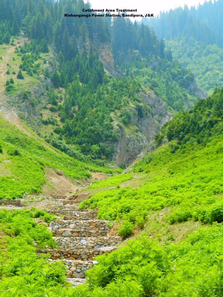
CATCHMENT AREA TREATMENT PLAN
The Catchment Area Treatment plan was a mandatory condition imposed by MOEF, Govt. of India while according environmental clearance to the project. Accordingly, CAT plan was prepared delineating the critically eroded areas, with the year wise financial and physical targets of various biological and engineering measures planned to be implemented in the five years duration. The plan was approved by MOEF on 12.12.1994. The CAT plan was prepared for improvement and upgradation of selected sub-watersheds of Rangit Catchment and the execution and implementation part was given to the State Forest Department of Sikkim State Government.
The CAT Plan was prepared with a financial outlay of Rs 11.00 crores (Rs 110 Million). The catchment area of Rangit Power Station consists of 26 sub-watersheds (SWS) covering an area of 979.02 sq km. After integrating soil type, soil depth, slope, landuse/land cover values under all the 26 SWS for generating the Erosion Intensity weightages, five and a half sub-watersheds have been considered for treatment (falling under very severe erosion intensity class) based on priority categorization made by All India Soil and Landuse Survey (AISLUS) i.e., 1) Tb 7a, 2) Tb7b, 3) Tb 6a, 4) Tb6b 5) Tb 5a, and 6) half the area of Tb5c.
IMPLEMENTATION OF CAT PLAN
The catchment area treatment work was taken up in phased manner (year wise) starting from 1995-96 and completed in 2002-03. The CAT plan was targeted towards over all improvement in the environment of catchment region. All the activities were aimed at treating the degraded and potential areas of severe soil erosion. The plan provides benefits due to biological and engineering measures, and its utility in maintaining the ecosystem. The plan with objectives addressed issues such as prevention of gully erosion, enhancing the forest cover for increasing soil holding capacity; and arresting total sediment flow in the reservoir and flowing waters.
Initially, the total physical target was 11,106 ha for biological treatment, 584 km for fencing, 2036 no. of protection walls and 4600 meters of catch water drains. During year 2000, a revised supplementary plan amounting to Rs 2,76,77,326/- was approved for the treatment of 1269 ha of balance area for the plantation and maintenance of old plantation/fencing and treatment of slips/slide areas. These areas were treated during 2000-01 and 2001-02 financial years in the revised plan period. In addition, two year for maintenance of old plantation/fencing was undertaken during 2002-2003 and 2003-2004. In total, thirteen sites covering 18 ha area in all the six sub-watersheds were developed as nurseries for raising the seedlings. These nurseries were developed in all the climatic zones of the catchment to ensure the better survival of the plants.
EFFECTIVENESS OF CAT PLAN
The implementation of CAT works started in 1995; as such in order to evaluate the effectiveness of the plan it was proposed to take up remote sensing based studies for the assessment of the works done under CAT. To assess the pre-project scenario, November 1994 satellite data of IRS-1B LISS-II was used and further post CAT status was evaluated by using IRS 1D LISS-III Imagery of December 2002 followed by IRS P6 LISS-III digital data of December 2006.
For the study, Erdas Imagine, Geomedia Professional and Arc View Software were used at different stages of the study. Survey of India (SOI) toposheets (Nos. 78A/2, 78A/6, 78A/3 and 78A/7) in 1:50,000 scale were used for the present study. The soil map prepared by NBSS & LUP, Nagpur for Sikkim in 1: 100,000 scales were subsetted as per the study area, in the study.
The slope map of the study area was prepared using Digital Elevation Modeling after digitizing the contours of the area at 200 meter intervals. The Landuse maps were prepared by unsupervised classification of the satellite data followed by supervised classification with the help of ERDAS Imagine software. The erosion status was evaluated based upon the integrated information on soil characteristics, physiography, slope and landuse/landcover. The composite map for delineating different erosion intensity units was prepared through superimposition of the above maps i.e. maps showing soil types, slope and landuse/landcover. This thematic mapping of erosion intensity for entire catchment was done using the overlay and union techniques.
The evaluation of three successive digital satellite data reveals that the objectives for which the CAT plan was implemented have been achieved satisfactorily. Based on GIS application, Landuse/Landcover statistics for the Rangit catchment up to dam site have been generated for pre-construction, during construction and post construction stages. The drainage map was extracted from SOI toposheets and the morphometry has been done. The details of landuse status are given in Table-1.
Table-1: Comparison of Landuse Status in Rangit River Catchment
| LANDUSE CATEGORY | Nov-94 | Dec-02 | Dec-06 | ||||
| Area
(in ha) |
% | Area
(in ha) |
% | Area
(in ha) |
% | ||
| Dense Forest | 38138 | 38.96 | 38011 | 38.82 | 33301 | 34.01 | |
| Open Forest | 1344 | 1.37 | 3367 | 3.43 | 16969 | 17.33 | |
| Degraded Forest | 2727 | 2.78 | 15044 | 15.36 | 12240 | 12.50 | |
| Agriculture | 16088 | 16.44 | 23161 | 23.65 | 9461 | 9.66 | |
| Alpine Vegetation | 11772 | 12.02 | 7298 | 7.45 | 9793 | 10.00 | |
| Alpine Barren | 4879 | 4.98 | 3376 | 3.44 | 6723 | 6.87 | |
| Fallow/Waste Land/ | 5075 | 5.19 | — | — | — | – | |
| Waterbody/Glacial Melts | — | — | — | — | 2074 | 2.12 | |
| Snow | 17879 | 18.26 | 7645 | 7.85 | 7342 | 7.50 | |
| Total | 97902 | 100 | 97902 | 100 | 97902 | 100.00 | |
It is evident that the forest cover is rapidly increasing with the time in the catchment. Dense and open forest category together has increased from 39482 ha in 1994 to 41378 ha in 2002 and then 50270 ha in the year 2006. The dense and open forest cover has increased from 40.33% to 51.34% in the area in 12 years. This is an encouraging success story of the CAT plan implementation. The decrease in degraded forest category is also noted by 2.86% in 2006 when comparing with 2002 status. The reduction in agricultural zones have been observed in satellite data of 2006 since the zoom cultivation is showing trend of reduction, which is also a positive sign.
Determination of erosion intensity unit is primarily based upon the integrated information on soil characteristics, physiography, slope and landuse/landcover. The analysis has been done for the sub-watersheds considered for treatment under the CAT plan. The composite map for delineating different erosion intensity units was prepared through superimposition of various maps i.e. maps showing soil types, slope and landuse/landcover. This thematic mapping of erosion intensity for catchment considered for treatment by biological and engineering measures were done using the overlay and union techniques. There has been remarkable decrease in very severe and severe erosion intensity category areas in the subsequent years. This is indicative of stability and reduction in sediment load contribution by streams and nallas into reservoir. Decrease in very severe and sever erosion zones in the sub-watershed after treatment explains that the CAT plan is basic approach towards sustainable development, and has been achieved in case of Rangit Project. The results show the effective implementation of the CAT plan.
Table – 2 : Comparison of erosion intensity classes between 1994, 2002 and 2006
| Category | Area (in Ha) | ||
| November-1994 | December-2002 | December 2006 | |
| Very Severe | 224 | 148 | 144 |
| Severe | 2754 | 2433 | 485 |
| Moderate | 4963 | 4483 | 3464 |
| Slight | 4121 | 5218 | 3233 |
| Negligible | 713 | 492 | 5320 |
| Snow/Data error | — | — | 95 |
| Total | 12775 | 12775 | 12775 |
On comparison of the landuse pattern in the Rangit catchment, it has been found that the impact of the project on the landuse is found to be minimal and positive results are observed. The analysis is based on the changes in landuse pattern between 1994 and 2006.
The results of the change detection analysis for Rangit catchment are given in Table 3 (a) and 3 (b). The Landuse classes analysed in 1994 was taken as base data for the change detection study and then the weightages values (positive, negative & no change) were assigned to the landuse classes identified in year 2002 and year 2006.
In areas where the degraded forest category has changed into dense or open category “positive” value has been assigned. Similarly, if dense forest is converted to open or degraded category then “negative” value is assigned. In a similar manner if there is no change in the time period of 12 years “no change” value has been assigned.
The overall performance of CAT plan in Rangit Project is found to be satisfactory. The objectives of the CAT plan have been achieved through an integrated approach comprising of both biological and engineering measures.
Table – 3 (a): Change detection analysis for entire Rangit Catchment
| S.No. | Change Detection | Area (in ha) | % |
| 1. | Positive | 62346 | 63.7 |
| 2. | Negative | 10902 | 11.1 |
| 3. | No changes | 24654 | 25.2 |
| Total | 97902 | 100 | |
Table – 3 (b): Change detection analysis of area under treatment in Rangit Catchment
| S.No. | SWS | Area (in Hectares) | |||||||
| Positive | % | Negative | % | No changes | % | Total | % | ||
| 1 | Tb5a | 1261 | 71.2 | 208 | 11.6 | 303 | 17.1 | 1771 | 100 |
| 2 | Tb5c | 1270 | 76.5 | 131 | 7.9 | 260 | 15.7 | 1661 | 100 |
| 3 | Tb6a | 1253 | 71.2 | 169 | 9.6 | 337 | 19.2 | 1759 | 100 |
| 4 | Tb6b | 1001 | 60.3 | 161 | 9.7 | 497 | 30.0 | 1659 | 100 |
| 5 | Tb7a | 2623 | 88.0 | 188 | 6.3 | 169 | 5.7 | 2979 | 100 |
| 6 | Tb7b | 2559 | 86.9 | 243 | 8.2 | 143 | 4.9 | 2946 | 100 |
| Total | 9967 | 78.0 | 1098 | 8.6 | 1709 | 13.4 | 12775 | 100 | |
CONCLUSION
The Rangit Power Station, since its inception has always given due emphasis on maintaining the harmonious blend between development and ecological systems. The post construction evaluation of CAT plan reveals that the objective for which the CAT plan was implemented i.e. reclamation of degraded areas in the catchment, have been fully achieved. The catchment area treatment works for Rangit Power Station which have been taken up in phased manner (year wise) starting from 1995-96 and completed by 2002-03 are showing positive results when compared with the satellite data of the year 1994 (before CAT plan implementation) and year 2006 (four years after CAT plan implementation).
The results are encouraging as there has been a decrease in the area under soil erosion category of ‘very severe’, ‘severe’ and ‘moderate’ category, however, the increase in the area under ‘slight category’ is due to increase in forest area. The area under agriculture has decreased substantially, since the areas have been converted to open and degraded forest category due to plantations under CAT plan. Being hilly terrain utmost care should be taken to avoid any faulty agricultural practices. The landslide stabilization has been achieved with the implementation of engineering measures which shows the satisfactory implementation of the engineering measures. Performance evaluation of the CAT plan based on certain indices show that the results are very encouraging. The successful implementation of CAT plan at Rangit project shows the commitment of NHPC in developing hydropower in a sustainable manner.

महासीर मछलियों का संरक्षण
आलेख: डॉ. अनिल कुमार त्रिपाठी, महाप्रबंधक (पर्या.); डॉ. सुजीत कुमार बाजपेयी, उप-महाप्रबंधक (पर्या.) ; मनीष कुमार, सहा. प्रबंधक (मत्स्य) [पर्यावरण एवं विविधता प्रबंधन विभाग, निगम मुख्यालय, फरीदाबाद]
महासीर Cyprinidae कुल में कार्प प्रजाति की मीठे पानी में पायी जाने वाली एक बड़ी एवं कठोर स्वभाव की क्रीड़ा मछली (Sport fish) मानी जाती है। ये प्रायः हिमालय से निकलने वाली नदियों और सहयाद्रि पहाड़ों से निकलने वाली अन्य नदियों में निवास करती हैं तथा अधिक ऑक्सीजन, भोजन एवं प्रजनन के लिए नदियों में चट्टानी सतह की ओर तेजी से आगे बढ़ती हैं। ये दुनिया में पाये जाने वाली 20 बड़ी प्रजातियों की मछलियों में से एक है, और इनकी अधिकतम लम्बाई 9 फुट और वजन 35-45 किलोग्राम रिकॉर्ड किया गया है, हालाँकि इस आकार की मछलियाँ शायद ही कभी दिखायी देती हैं। औसतन 5 से 8 किलोग्राम की मछली भारतीय नदियों में प्रायः देखने को मिल जाती हैं।
वितरण:
दुनिया में मौजूद महासीर की कुल 47 प्रजातियों में से भारत में केवल 15 प्रजातियाँ पायी जाती हैं, जिनमें Tor putitora (गोल्डेन महासीर), Tor tor (टौर महासीर), Tor khudre (डेक्कन महासीर), Tor mussullah (हम्पबैक महासीर), Tor kulkarnii (ड्वॉर्फ महासीर), Tor progeneius (जंघा महासीर), Tor mosal (कॉपर महासीर), Tor mahanadicus (महानदी महासीर), Tor malabaricus (मालाबार महासीर) एवं Neolissocheilus hexagonolepis (चॉकलेट महासीर) प्रसिद्ध है। इन प्रजातियों में से केवल दो प्रजातियाँ (Tor putitora एवं Tor tor) गंगा बेसिन में पायी जाती हैं। इन सभी महासीर मछलियों में गोल्डेन महासीर, हिमालयन बेल्ट के ऊपरी भू-भाग के उत्तर-पश्चिम में कश्मीर से लेकर पूर्वोत्तर में सदिया तक सबसे ज्यादा पायी जाती है। गोल्डन महासीर हिमालय की तलहटी, इंडस, गंगा और ब्रह्मपुत्र घाटियों में पाई जाती है और इन्हें दक्षिण में भी बालामोर, कावेरी, तंबरपरिणी नदियों में देखा जा सकता है।
गंगा नदी में गोल्डन महासीर देवप्रयाग और ऋषिकेश के बीच वितरित हैं, हालांकि कभी-कभी ये देवप्रयाग के ऊपर भी कम दूरी के लिए प्रवासन करती हैं। कुछ दशक पहले यह हरिद्वार तक पायी जाती थी, पर अब बाढ़ के दौरान एवं उसके उपरांत के समय को छोडकर इनका यहाँ पाया जाना दुर्लभ ही माना जाता है।
जीवविज्ञान: आम तौर पर महासीर मछली, बाढ़ के दौरान रॉकी और बजरी स्थानों के ऊपर अक्सर अल्पकालिक जल शीर्ष पर 6,000 से 10,000 प्रति किलो शारीरिक वजन की दर से अंडे देती है। इनकी अंगुलिकाएं (fingerlings) सालाना 10 सेमी की औसत दर से बढ़ती है। सामान्यतः महासीर कॉलम एवं बॉटम फीडर प्रवृति की होती है। अन्य कार्प के तरह यह भी सर्वग्राही होती है एवं फल, शैवाल, क्रसटेशियन, कीड़े, मेंढ़क के साथ साथ अन्य छोटी मछली भी खाया करती हैं। माइग्रेशन के दौरान यह मांसाहारी हो जाती है, जबकि 46 सेमी से बड़ी आकार की महासीर लगभग मत्स्यभक्षी हो जाया करती है।
गोल्डन महासीर अपने समूह की सबसे बड़ी प्रजाति है और यह पहाड़ी प्रवाह में रहना पसंद करती है, जहाँ चट्टानी और पथरीले सब्सट्रेट मिलते हैं। यह 5 0C से 25 0C तापमान के मध्य अपना जीवन-यापन करती है। अतः ये न तो गर्म जलवायु की तराई में, और न ही बहुत अधिक ठंडी जलवायु की धाराओं में पायी जाती है।
प्रवासन और प्रजनन: सामान्यतः भारतीय नदियों में मछलियों का प्रवासन तीन प्रकार से होता है, एनाड्रोमस प्रवासन (Anadromous Migration), जिसमें मछलियाँ प्रजनन के लिए समुद्र से नदी की ओर, अर्थात खारे पानी से मीठे पानी की ओर पलायन करती है; केटाड्रोमस प्रवासन (Catadromous Migration), जिसमें मछलियाँ प्रजनन के लिए नदी से समुद्र की ओर, अर्थात मीठे पानी से खारे पानी की ओर पलायन करती है; तथा पोटेमोड्रोमस प्रवासन (Potamodromous Migration), जिसमें मछलियाँ प्रजनन के लिए नदियों में अप-स्ट्रीम की ओर पलायन करती है। महासीर की प्रजाति नदियों में पोटेमोड्रोमस प्रवासन (Potamodromous Migration) के लिए जानी जाती है।
गोल्डन महासीर लगभग 45 सेमी (4+ वर्ष) के आकार को प्राप्त करने के बाद परिपक्व होती है। समान्यतः मई से सितंबर महीने के दरम्यान गोल्डन महासीर अप-स्ट्रीम की ओर प्रजनन स्थलों जैसे सहायक नदियों एवं नदियों के किनारों की ओर प्रवासन करती है। अगस्त-सितंबर के समय स्पोनिंग (अंडे देना) के बाद अक्टूबर से दिसंबर के मध्य डाउन-स्ट्रीम की ओर पलायन कर वापस आ जाती है। यह पत्थर और कंकड़ सब्सट्रेट पर छिछले एवं हल्के उष्ण पानी में अंडे देती है, जो कि 60-96 घंटे में हैच (निषेचित अंडे से बच्चे निकलना) करती है। टौर महासीर लगभग 36 सेमी (3+ वर्ष) के आकार को प्राप्त करने के बाद परिपक्व होती है और ये समान्यतः जून से सितंबर महीने के दरम्यान अप-स्ट्रीम की ओर प्रवासन करती है। टौर महासीर मई-अगस्त के दरम्यान स्पोनिंग (Spawning-अंडे देना) करने के उपरांत अक्टूबर से दिसंबर के मध्य डाउन-स्ट्रीम की ओर पलायन कर वापस आ जाती है। इसी तरह चॉकलेट महासीर भी लगभग 19-25 सेमी (2-3 वर्ष) के आकार को प्राप्त करने के बाद परिपक्व होती है। ये समान्यतः मई से सितंबर महीने के दरम्यान अप-स्ट्रीम की ओर प्रवासन करती है, जो अगस्त-सितंबर के दरम्यान स्पोनिंग (अंडे देना) होने के पश्चात अक्टूबर से दिसंबर के मध्य डाउन-स्ट्रीम की ओर पलायन कर वापस आ जाती है। जुवेनाइल मछली (मछली के बच्चे) पानी की तीव्र धारा और मांसाहारी मछलियों से बचने के लिए कुछ समय प्रजनन क्षेत्र में ही व्यतीत करती है, जबकि ब्रूडर मछली (Brooder Fish – अंडे देने के लिए तैयार परिपक्व मछली) स्पोनिंग के बाद तलहटी की ओर लौट आती है।
महासीर की संख्या में आयी हुई कमी के मुख्य कारण निम्नलिखित हैं:
- जलीय प्रणालियों की पारिस्थितिकी में आयी गिरावट।
- ब्रूडर (Brooder) मछली और जुवेनाइल मछलियों की अंधाधुंध फिशिंग।
- बड़ी नदी-घाटी परियोजनाओं के कारण महासीर के प्रवासन में होने वाली बाधाओं के आंशिक प्रभाव।
- औद्योगिकीकरण एवं मानव द्वारा जल-प्रदूषण।§ शिकारियों द्वारा विस्फोटक, विष और इलेक्ट्रो-फ़िशिंग का प्रयोग करना।
- विदेशी प्रजातियों का अपनाया जाना।
संरक्षण: भारत में Tor putitora को अरुणाचल प्रदेश, हिमाचल प्रदेश, उत्तराखंड एवं जम्मू-कश्मीर राज्य की राजकीय मछली, जबकि Tor mahanadicus को ओडिशा राज्य की, और Neolissocheilus hexagonolepis को नागालैंड राज्य की राजकीय मछली घोषित किया गया है, ताकि इनका संरक्षण उच्च पैमाने पर किया जा सके।
भारत में पाये जाने वाले महासीर प्रजातियों में से Tor putitora को IUCN के रेड लिस्ट में ‘लुप्तप्राय प्रजाति’ के रूप में, जबकि Tor tor को ‘संकटग्रस्त के नजदीक’ के रूप में सूचीबद्ध किया गया है। भारत में भी भारतीय कृषि अनुसंधान परिषद– राष्ट्रीय मत्स्य आनुवंशिक संसाधन ब्यूरो, लखनऊ द्वारा वर्ष 2010 में महासीर की प्रजातियों जैसे Tor putitora, Tor tor, Tor mussullah, Tor progeneius, Tor mosal एवंTor malabaricus को ‘लुप्तप्राय प्रजाति’ के रूप में, जबकि Tor khudre को ‘अति संवेदनशील स्थिति’ के रूप में सूचीबद्ध किया गया है। यद्यपि अभी भी हिमालयन और मध्य भारतीय नदियों में एंगलिंग पर्यटन को बनाए रखने के लिए इनकी संख्या पर्याप्त है।
नदियों के कुछ निर्दिष्ट हिस्सों को जल अभयारण्य घोषित करने से, बंद मौसम (Low flow/ Lean season) में मछली पकड़ने पर प्रतिबंध लगाने से, आरक्षित हिस्सों में केवल रॉड और लाइन का प्रयोग करने से और कैच लिमिट पर अमल करने से इनकी आबादी पर सकारात्मक प्रभाव पड़ सकता है, जिससे इनकी पुनर्वास किसी निश्चित क्षेत्र में संभव हो सकेगी। कुछ-कुछ जगहों पर इनके संरक्षण को बढ़ावा देने के लिए नदियों पर मछली पकड़ने के लिए अस्थायी पत्थर बांध के निर्माण एवं जुवेनाइल मछली जाल के उपयोग को वर्जित रखा गया है।नदी घाटी परियोजनाओं के कारण महासीर के प्रवासन में बाधा पहुँच सकती है । बांध के कारण महासीर के प्रवासन में आ रही बाधा को दूर करने के लिए कई कम ऊँचाई वाले बाँधों / जलविद्युत परियोजनाओं में फिश-पास/ फिश-लेडर का निर्माण भी किया गया है। देश में निर्मित कुछ ऐसी बांध/ जलविद्युत परियोजनाएँ जहाँ फिश लैडर का निर्माण किया गया है, वे निम्नलिखित हैं:
भारत में निर्मित फिश लैडर (महासीर उपयुक्त) का विवरण :
| क्रम संख्या | बांध/बैराज | निर्माण वर्ष | नदी | राज्य |
| 1. | माधोपुर | 1928 | रावी | पंजाब |
| 2. | रोपर | 1882 | सतलज | पंजाब |
| 3. | बनबस्सा | 1928 | शारदा | उत्तराखंड |
| 4. | नरोरा | 1967 | गंगा | उत्तरप्रदेश |
| 5. | फिरोजपुर | 1927 | सतलज | पंजाब |
| 6. | टनकपुर (एन एच पी सी) | 1993 | शारदा | उत्तराखंड |
| 7. | उरी-I (एन एच पी सी) | 1997 | झेलम | जम्मू & कश्मीर |
| 8. | हथनीकुंड | 1999 | यमुना | हरियाणा |
| 9. | लारजी | 2006 | व्यास | हिमाचल प्रदेश |
| 10. | तीस्ता लो डैम –III (एन एच पी सी) | 2013 | तीस्ता | पश्चिम बंगाल |
| 11. | तीस्ता लो डैम –IV (एन एच पी सी) | 2016 | तीस्ता | पश्चिम बंगाल |
कृत्रिम प्रजनन:महासीर के कृत्रिम प्रजनन सफलताओं ने इनके पुनरुद्धार की संभावनाओं पर नई उम्मीद जगाई है। अब ‘महासीर सीड रेंचिंग प्रोग्राम’ के जरिये बड़े पैमाने पर जलाशयों एवं नदियों में महासीर का पुनर्वास किया जा रहा है। इसी के अंतर्गत जहाँ बांध एवं बराज की ऊँचाई ज्यादा है, वहाँ बांध के दोनों तरफ सीड रेंचिंग किया जा रहा है।
महासीर की चार प्रजातियों )Tor khudree, Tor mussullah, Tor putitora और Tor tor) का कृत्रिम प्रजनन संभव हो पाया है। इसके लिए ब्रूडर (अंडे देने हेतु तैयार परिपक्व मछली) को नदी से पकड़ कर हाइपोफाईजेशन तकनीक (Hypophysation Technique – अन्य मछली की पिट्यूटरी ग्रन्थि के तत्व को निकालकर ब्रूडर मछलयों में इंजेक्शन द्वारा प्रेरित कर आसानी से कृत्रिम प्रजनन कराने का तकनीक) के द्वारा पानी की कृत्रिम धारा प्रवाह की मदद से सफल प्रेरित प्रजनन (Induced Breeding) किया जाता है। इस तकनीक में ब्रूडर मछली को ओवाप्रीम/ ओवाटाइड का इंजेक्शन लगाने के बाद स्ट्रीपिंग (Stripping) के जरिये भी अंडे (मादा अंडाणु) एवं मिल्ट (नर शुक्राणु) निकाल कर इनका निश्चित फर्टिलाइजेशन किया जाता है।
एनएचपीसी के विभिन्न जल-विद्युत परियोजनाओं जैसे हिमाचल प्रदेश में स्थित चमेरा-II, चमेरा-III, पार्बती-II एवं पार्बती-III पावर स्टेशन; जम्मू & कश्मीर में स्थित चुटक, निम्मो-बाजगो, सेवा-II एवं उरी-II पावर स्टेशन तथा सिक्किम में स्थित तीस्ता-V पावर स्टेशन में मत्स्य प्रबंधन योजना (Fisheries Management Plan) के अंतर्गत फिश-फार्म/ फिश हेचरी की स्थापना की गयी है, जहाँ कृत्रिम प्रजनन की सहायता से मछलियों का बीज उत्पादन किया जाता है। इन फिश-फार्म/ फिश हेचरी का मुख्य उद्देश्य नदी घाटियों का पारिस्थितिक विकास एवं आसपास के क्षेत्र के किसानों को तकनीकी सुविधाएँ मुहैया करा कर एवं मछलियों का बीज (Fry/ Fingerling) उपलब्ध करा कर उन्हें इस क्षेत्र में समृद्ध बनाना है। एनएचपीसी द्वारा रेंचिंग प्रोग्राम के तहत नदी-घाटियों के पारिस्थितिक विकास के लिए मछलियों के अंगुलिकाओं (fingerlings) को नदी में स्टॉक भी किया जाता है।
‘राष्ट्रीय महासीर मछली फार्म’ की स्थापना: महासीर के महत्व को ध्यान में रखते हुए एवं हिमाचल प्रदेश सरकार द्वारा किए गए अथक प्रयासों के मद्देनज़र भारत सरकार ने 2.00 करोड़ रुपये की वित्तीय सहायता से हिमाचल प्रदेश राज्य में एक ‘राष्ट्रीय महासीर मछली फार्म‘ की स्थापना के राज्य सरकार के प्रस्ताव को मंजूरी दे दी है। यह नदियों एवं बाँधों के खुले पानी और ऐसे सभी संभावनाओं को देखते हुए लंबे समय से चली आ रही महासीर बीज प्रत्यारोपण की मांग को पूरा करने में सक्षम होगा।
डब्लूडब्लूऍफ़-इंडिया भी गोल्डेन महासीर के सर्वेक्षण के बाद उत्तराखंड में कोसी नदी के 30 किलोमीटर क्षेत्र में ‘प्रजाति प्रबंधन योजना’ तैयार करने की प्रक्रिया में है। डब्ल्यूडब्ल्यूएफ रिपोर्ट द्वारा भारत में महासीर संरक्षण पर विभिन्न सरकारी और वैज्ञानिक विभागों और समुदाय के प्रतिनिधियों के विशेषज्ञों को शामिल कर एक संचालन समूह की स्थापना, महासीर ‘संरक्षण भंडार’ की स्थापना, समुदाय आधारित मछली पकड़ने, और जागरूकता एवं क्षमता निर्माण के सुझाव दिये गए हैं।
(यह आलेख राजभाषा ज्योति के सितंबर 2017 अंक मे प्रकाशित हुआ है)
पर्यावरण वार्ता (अंक 2)
यह हर्ष की बात है कि पर्यावरण विभाग के ब्लॉग का विधिवत प्रारंभ, निगम के अध्यक्ष एवं प्रबन्ध निदेशक श्री बलराज जोशी के द्वारा दिनांक 28/02/2019 को वार्षिक पर्यावरण बैठक के दौरान किया गया। इस अवसर पर उन्होंने यह अपेक्षा की है कि ब्लॉग के माध्यम से निगम द्वारा पर्यावरण के क्षेत्र में किए जा रहे कार्यों की जानकारियों को व्यापक स्तर पर पहुँचाया जा सकेगा। ब्लॉग जैसा शक्तिशाली सोशल माध्यम एनएचपीसी एवं इसके अन्य हितधारकों से सीधा संवाद स्थापित करने में सक्षम है।
पर्यावरण संरक्षण के लिए एनएचपीसी की प्रतिबद्धता इस बात से सुनिश्चित होती है कि वर्ष में एक बार निगम मुख्यालय/ क्षेत्रीय कार्यालय/ परियोजनाओं/ पावरस्टेशनों मे पदस्थ सभी पर्यावरण अधिकारी एकत्रित हो कर अपने कार्यानुभव ही साझा नहीं करते अपितु उन्हें विषय विशेषज्ञों के अनुभवों का लाभ भी प्राप्त होता है। यह हर्ष का विषय था कि इस वर्ष भी दिनांक 28 फरवरी से 1 मार्च, 2019 के मध्य पर्यावरण अधिकारियों की वार्षिक बैठक सम्पन्न हुई जिसमें एनएचपीसी के अतिरिक्त एनएचडीसी तथा सीवीपीपी से आए पर्यावरण अधिकारियों ने भी प्रतिभागिता की।
पर्यावरण का संरक्षण छोटी-छोटी गतिविधियों से भी सुनिश्चित किया जा सकता है। उदाहरण के लिए पर्यावरण अधिकारियों की बैठक में आगंतुक अतिथियों और वक्ताओं का स्वागत पौधा प्रदान कर किया गया। धरती की हरियाली बढ़ाने के लिए बूंद-बूंद की पहल ही सागर भर सकती है। कार्यक्रम के अवसर पर अतिथियों को “सॉन्ग ऑफ़ इंडिया” नामक पौधा प्रदान किया गयाI इस चर्चित पौधे की चालीस से अधिक प्रजातियाँ विद्यमान हैं। यह एक लोकप्रिय सजावटी पौधा है जिसका वैज्ञानिक नाम ड्रैकैना रिफ्लेक्सा हैI यह एक अत्यंत प्रभावशाली घरेलू वायु शोधक पौधा भी माना जाता है जो हानिकारक तत्वों को 24 घंटों में अवशोषित कर 87 % तक वातावरण शुद्ध बना देता है। इतना ही नहीं, यह पौधा ग्रहण किए गए जल का 97% वापस मुक्त कर घर के अंदरूनी वातावरण की नमी को बढ़ाता है जिससे श्वांस की तकलीफ में राहत मिलती है। कथनाशय यह है कि एक पौधे का रोपण और संरक्षण भी पर्यावरण के संवर्धन में बड़ा कदम होता है। हरियाली बढ़ायें और हरियाली फैलायें। यह भी जोड़ना प्रासंगिक होगा कि इस वर्ष विश्व पर्यावरण दिवस “प्लास्टिक प्रदूषण को परास्त करें” के सूत्र वाक्य पर केंद्रित था। इसे ध्यान मे रख कर वार्षिक पर्यावरण बैठक में सभी प्रतिभागियों एवं आमंत्रित अतिथियों को जूट के बने बैग प्रदान किए गये थे जिनपर लिखवाया गया था – “BEAT PLASTIC POLLUTION – IF YOU CAN’T REUSE IT, REFUSE IT”
होली का त्यौहार निकट है। प्रत्येक भारतीय त्यौहार हमें सौहार्द का संदेश प्रदान करते हैं। संभव हो तो होली में रासायनिक रंगों से बचाव करें। यह समय प्रकृति के उत्सव का है, वसंत की ऋतु है। पलाश-अमलताश से परिवेश रंग-बिरंगा है और इन फूलों से बनने वाले गुलाल न तो त्वचा को हानि पहुंचायेंगे न ही पर्यावरण को कोई नुकसान। पानी की बचत भी आवश्यक है क्योंकि जल से ही जीवन है। होली खेलने हेतु पानी में जब रंग मिलायें तो यह ध्यान में रखें कि वह रासायनिक न हो। सभी को होली की हार्दिक शुभकामनायें।
अरुण कुमार मिश्रा
कार्यपालक निदेशक (पर्यावरण एवं विविधता प्रबंधन)
जनभागीदारी से पर्यावरण संरक्षण के लिए प्रतिबद्ध पारबती चरण II परियोजना, हिमाचल प्रदेश
एनएचपीसी की सभी परियोजनायें पर्यावरण संरक्षण के लिये प्रतिबद्ध हैं। हिमाचल प्रदेश में अवस्थित पारबती जलविद्युत परियोजना, चरण – II का उदाहरण लेते हुए इसे समझने का यत्न किया जाये तो न केवल पौधारोपण अथवा पर्यावरण प्रभाव मूल्यांकन अध्ययन को आधार बना कर प्रतिपूरक वनारोपण, जलागम उपचार आदि कार्य किये जाते हैं, बल्कि जनभागीदारी के माध्यम से भी संवर्धन को सुनिश्चित किया जाता है। इन जनभागीदारी कार्यक्रमों में यह भी प्रयास किया जाता है कि एनएचपीसी के परियोजनाओं एवं उनमें किए जा रहे पर्यावरण प्रबंधन योजनाओं के बारे में विस्तृत जानकारी भी प्रतिभागियों तक पहुंचाई जाएI इस तरह के कार्यक्रम परियोजना एवं उसके निकटवर्ती क्षेत्र के बीच निरंतर संवाद स्थापित करने में भी सहायक होते हैंI इस कड़ी में उल्लेखनीय है कि दिनांक 6 अक्टूबर, 2018 को पारबती जलविद्युत परियोजना, चरण – II द्वारा रैला ग्राम पंचायत में जन-सामान्य के लिये पशुपालन पर केंद्रित एक प्रशिक्षण कार्यक्रम का आयोजन किया गया था। पशुपालन किसी भी ग्रामीण अर्थव्यवस्था की रीढ़ होता है। पशुपालन के लिये प्रोत्साहन और वैज्ञानिक सोच ग्रामीणों में प्रसारित करना सतत विकास की अवधारणा का पोषण है। रैला गाँव में आयोजित एक दिवसीय पशुपालन प्रशिक्षण कार्यक्रम को एनएचपीसी द्वारा राज्य पशुपालन विभाग के सहयोग से आयोजित किया गया था। इस कार्यक्रम में ग्रामीणो को मवेशियों के पालन, पशु में होने वाले विभिन्न रोगों व इसके रोकथाम के उपायों की महत्वपूर्ण जानकारी प्रदान की गयी। इसके अतिरिक्त ग्रामीणों को मवेशियों के जीवनचक्र के अनुसार उन्हें संतुलित आहार देने के विषय में भी बताया गया। प्रशिक्षण कार्यक्रम में पशु पालन विभाग, कुल्लू से डॉ अंचल शर्मा, पशु चिकित्सक एवं सेंज से डॉ अष्मिता आनंद, पशु चिकित्सक ने प्रतिभागिता की। पार्बती परियोजना से श्री शरद भटनागर, प्रमुख (भूविज्ञान) तथा श्री प्रताप कुमार मल्लिक, वरिष्ठ प्रबन्धक (पर्यावरण) उपस्थित थे। साथ ही श्रीमती खिम दासी (पंचायत प्रधान, रैला), श्री बालमुकुंद,उप प्रधान, रैला व रैला ग्राम पंचायत से 18 पुरुष प्रतिभागी एवं 14 महिला प्रतिभागियों ने कार्यक्रम में सहभागिता की और पशुपालन क्षेत्र में नयी तकनीकों की जानकारी प्राप्त कर लाभ उठाया। प्रशिक्षण उपरांत परियोजना द्वारा प्रतिभागियों को अपने पशुओं को निरोग रखने हेतु नि:शुल्क दवाइयाँ भी वितरित की गयीं।
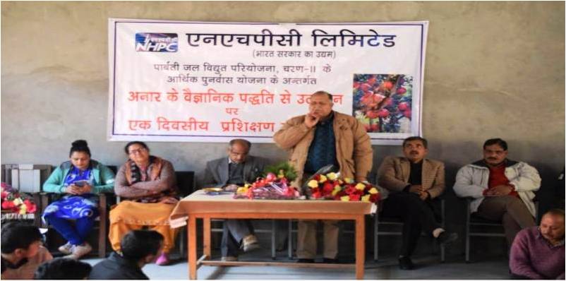
इसी कड़ी में पारबती जलविद्युत परियोजना, चरण – II द्वारा निकटस्थ ग्रामवासियों को अनार की खेती के नवीनतम तरीकों से परिचित कराने के उद्देश्य से दिनांक 18 जनवरी, 2019 को एक दिवसीय कृषि प्रशिक्षण कार्यक्रम का आयोजन पंचायत भवन, गड्सा में किया गया। यह कार्यक्रम क्षेत्रीय बागवानी अनुसंधान केंद्र, बंजौर के सहयोग से सम्पन्न हुआ। कार्यक्रम के मुख्य अतिथि डॉ. एच. एस. भाटिया, सह-निदेशक, क्षेत्रीय अनुसंधान केंद्र, बजौर थे। इस अवसर पर डॉ. बी. एस. ठाकुर (वैज्ञानिक), डॉ.विजय कुमार भारद्वाज (वैज्ञानिक) भी उपस्थित थे तथा उन्होंने अनार की खेती के विविध तरीकों और उन्हें लगाने में सावधानियों से ग्रामीणों को परिचित कराया। डॉ. एच. एस. भाटिया ने अपने वक्तव्य के द्वारा ग्रामीणों को अनार की खेती करने की वैज्ञानिक पद्धति व तौर-तरीकों से सरल शब्दों में अवगत कराया जिससे कि किसान अनार की भरपूर फसल पैदाकर, अपनी आर्थिक स्थिति सुधार सकें। इस अवसर पर उन्होंने अनार के पौधों की बुआई, सिंचाई व देखभाल की भी विस्तृत जानकारी दी। अगले वक्ताओं के रूप में डॉ. बी. एस. ठाकुर व डॉ.विजय कुमार भारद्वाज ने भी अनार में लगने वाली बीमारियों और इनसे बचने के उपाय के विषय में किसानों को आवश्यक जानकारी प्रदान की। उन्होंने ग्रामीणों की फसल संबंधी अन्य समस्याओं का भी समाधान इस प्रशिक्षण के माध्यम से किया। मुख्य महाप्रबंधक (भू-विज्ञान/पर्यावरण), श्री एस. एल. कपिल ने इस अवसर पर बोलते हुए एनएचपीसी की उपलब्धियां, परियोजना की वर्तमान स्थिति तथा परियोजना प्रभावित परिवारों के विकास के लिए पर्यावरण प्रबंधन योजना के अंतर्गत किये जा रहे कल्याणकारी योजनाओं के विषय में ग्रामवासियों को अवगत कराया। कार्यक्रम के अंत में गड्सा ग्राम पंचायत में 2000 अनार के पौधों का वितरण किया गया। प्रत्येक प्रभावित परिवार को 25-25 अनार के पौधे दिये गए। कार्यक्रम में बडी तादाद में ग्रामीण उपस्थित थे साथ ही श्रीमती चित्रलेखा देवी ग्राम-प्रधान, गड्सा ने भी इसमें सहभागिता की। पारबती जलविद्युत परियोजना, चरण – II की ओर से श्री एस. एल. कपिल मुख्य महाप्रबंधक (भू- विज्ञान/पर्यावरण); श्री महेश टंडन, उप-महाप्रबंधक (सिविल) एवं श्री प्रताप मल्लिक वरिष्ठ प्रबन्धक (पर्यावरण), उपस्थित थे।
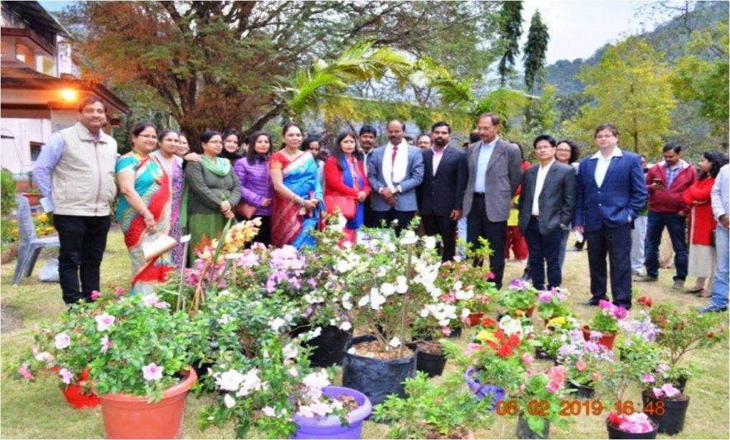
FLOWER SHOW ORGANISED IN TEESTA-V POWER STATION
For the first time, two days “Flower Show” was organised in Teesta-V Power Station on 8th– 9th Feb’2019 wherein various flowering/ornamental plants & orchids have been displayed with an objective to spread awareness about the native flowering plants & orchids and to inculcate and promote the habit of growing these plants/flowers. Total 22 participants including local people and nurseries from neighbouring areas showcased attractive collection of plants. The event was inaugurated by Mrs. Nibedita Khatua, President, Teesta-V Ladies Welfare Association in the presence of Shri Sahadev Khatua, General Manager In-charge, Colonel Deepak Suri and other Officials of Teesta-V Power Station. The show was visited and highly appreciated by the employees of Teesta-V, their families, students and teachers of Kendriya Vidyalaya and local villagers from far-flung areas.
The closing ceremony was attended by Shri M. L. Srivastava, Principal Secretary-cum-PCCF, Forest, Environment & Wildlife Management Department, Govt. of Sikkim on 9th Feb’2019. Winners were awarded with Trophies in categories viz. Flowering Plants, Ornamental Plants and Orchids. All the participants were felicitated with participation trophies. The show was concluded with thanks by Dr. A. K. Jha, Senior Manager (Environment). The two days “Flower Show” which was first of its kind by any power station proved to be a big success.
PHOTOGRAPH OF THE WEEK
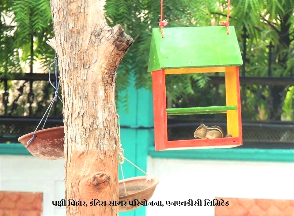
Photograph is from “Pakshi Vihar” established at Indirasagar Power Station, NHDC LTD (A Joint Venture of NHPC LTD and Govt. Of Madhya Pradesh). This area in outer part of project colony was isolated and neglected as such, it was selected by Project Environment Division as site for “Pakshi Vihar”. Various fruit bearing trees for example Gular, Jamun, Achar, Badam, Kadamb etc were planted with a planning to attract various native as well as migratory birds at this site. A small pond was constructed to attract birds as well as “pakshi Pyau” (hanging mud pots) were placed at various places and hanged over branches of trees for their drinking water facility. Provision are made to place various kind of grains such as Rice, Wheat, Bajra, Jwar etc every morning at Pakshi Vihar site. These efforts started attracting variety of birds at this site and many of them started preparing nests at around surrounding areas. To encourage bird nesting at “Pakshi Vihar Site” attractive manmade nests have also been prepared with help of waterproof plywood. These nests were placed over many trees at pakshi vihar. It is encouraging that most to the manmade nests are now occupied by various kind of birds and the site has started attracting lot of visitors for birdwatching. This project has attracted media and social-media, also this afforts have been appreciate by Forest Department and MP Pollutuon Control Board.
Local Area Development through Hydropower Project: A Case Study of Parbati Hydro-Electric Project Stage-III (520MW) in Kullu district of Himachal Pradesh (India)
Paper by: Ashish K Dash, Dy. General Manager (Environment) and Manoj K. Singh, Sr. Manager (Environment); Environment and Diversity Management Division, NHPC Ltd.
The objective of study is to assess and evaluate the Local area development (LAD) in Sainj valley following the start of construction of Parbati HE Project-III in the Year 2006 by NHPC Limited (a Government of India Enterprise- miniratna). The assessment of local area development is based on comparison of baseline data of Sainj area prior to start of construction of project and data available during construction phase of project followed by reviewing of Govt. policy for Local Area Development Fund (LADF) in project affected area and consultation with people from project affected gram-panchayats located in the vicinity of construction sites to know their perception about the role of Parbati hydroelectric Project Stage-III in local area development of Sainj valley. The result of study shows that there is substantial increase in developmental activities in and around the project area due to the construction of Parbati HE Project-III. Particularly, infrastructural development (road-bridge) led to improvement in communication and accessibility of villages (Manham, Banau, Sapangini,Talara) in Sainj valley, better transport facility for horticulture products of farmers in Sainj valley to nearby market located on NH-21. The prospects of job opportunities in Project construction works, ancillary activities and in petty contract works also improved. Implementation of community development Schemes of NHPC led to availability of additional medical facilities, educational facility in Govt. Schools and development of socio-cultural aspects (Crematorium, melaground, toilets,watersupply etc) in Sainj valley are attributed to the construction of Parbati HEP-III. During construction phase of the project, in compliance to Govt. policy for LADF @ 1.5% of project cost allocated for execution of developmental works resulted in source of specific fund for development opportunity in Project affected area(PAA) in the valley and nearby areas. Out of total LADF for PAA, 60% was shared equally among three project affected gram-panchayats and remaining 40% among 04 gram-panchayats for taking-up developmental works by resolution of Gram-Shaba and local area development Committee(LADC). Also, during operational phase of Project, the provision of LADF @ 1% share of free power and revenue equivalent to 12% share of free power to State Govt. of Himachal Pradesh from Parbati HEP-III on annual basis through-out the life span of project are continuous source of financial gain from Parbati HEP-III which will act as a stimulus for development.
Introduction
The Indian Himalayan Region (IHR) with its major river systems and variation in topographical features has vast hydropower potential to generate electricity from flowing water with a hydraulic gradient (Price, T. and Probert D, 1997). IHR accounts for 67% of Himalayan region and approximately 18% of India’s total geographical area and contrarily own more than 75% (117.139 MW) of total exploitable potential (Agrawal DK et al., 2001). Harnessing of hydroelectric potential are in different stages of development like operation, construction and investigation stages. The people of IHR, like elsewhere in other mountain ecosystem, are heavily dependent for their livelihood on their immediate natural resources and production from primary sectors such as agriculture, forestry, horticulture, livestock, etc. Despite the abundance of natural resources, most of its people are marginalized and still live on subsistence level (Singh, 2006). Sustainable harnessing of hydropower projects (HPPs) in IHR offer a means of local area development around project area in particular and provide clean, economic and renewable source of electricity to the nation.
There is close linkage between energy and the social dimension of the sustainable development. Energy is absolutely essential to deliver adequate services, food, water, health care, education, shelter, and employment and therefore the access to sustainable energy is a key factor for promoting social progress and economic growth (Najam and Cleveland, 2008, Kahssay and Mishra, 2013; Goldemberg and Johansson, 1995). In our increasingly carbon constrained world, renewable energy forms, such as hydropower and wind power, have the potential to meet the economic, social, environmental, and sustainability criteria demands of our times(Paul Schuler 2007). Hydropower is a renewable and green source of energy, which is economic (Chandrasekharan,1995; Subrahmanyam 2013) reliable to manage fluctuation of electric power and has flexibility to open and close gate to control demand of power (Bhoi & Ali, 2014). It is the least expensive source of electricity when compared to nuclear and coal plants (Singh et al, 1991). Hydroelectric projects have long useful life extending over 50 years and help in conserving scarce fossil fuels (CEA, 2008).
At the World Summit on Sustainable Development (Johannesburg in 2002), a commitment was made to increase hydropower production as a means of addressing environmental concerns and the successful initiation of the hydroelectric project may also contribute in obtaining the Millennium Development Goal(MDG) put forth by United Nation (Kahssay and Mishra, 2013).
Looking into the perspective of social dimension of Sustainable development, basic infrastructure such as Roads, reliable supply of electricity, water supply, health facilities etc is required for a particular region. The setting-up of HPPs in IHR offer a prospect of development of local area. Generally, during the planning and preliminary investigation stage of HPPs, the best alternative site are selected on the basis of hydraulic gradient (net head), flow regime and minimum displacement of inhabitants as well as impact on environment. On techno-economic evaluation, suitable sites for hydropower project appurtenance such as water diversion structure (dam/barrage), tunnel, powerhouse etc are located in remote hill terrain which lacks proper access road, bridge and other civic infrastructure facility such as water supply lines, hospitals, markets, reliable supply of electricity etc (Subrahmanyam-2013).
Implementation of HPPs in such area is challenging in view of topographical features, fragile ecology and compliance of environmental norms as per conditional statutory clearances and budget accorded by Government. In order to ensure timely and cost-effective implementation of HPPs in such area, infrastructural facilities like construction of access road, bridges, strengthening of existing bridge and widening of existing roads, efficient and reliable tele-communication links, better rail transport, post- office, bank, market etc are developed at a faster pace by expeditious efforts of project developers with the help of local Govt. machinery. Development of these infrastructures in the region also help in opening avenues for development of remote and hitherto backward hilly areas by giving accessibility of these facilities and connectivity to nearby town to increase socio-economic activities. On start of Project construction activities, the scope of employment in construction works, self employment in project ancillary works and marketing avenues are increased. The study conducted by Panwar et al 2013, Subrahmanyam 2013, Bose et al., 2001 and Altinbilek, 2002, indicates that Hydropower projects create many direct jobs and associated demands for goods and services besides infrastructures i.e., electricity, roads, water supply and distribution network etc., which act as stimulus for further development and economic growth both in direct and indirect way. All these facilities help in local area development and improving the quality of life of the inhabitants. After commissioning of project, supply of clean and cheap electricity boost the industrial development of area. Hydropower projects contribute much more than renewable energy through the storage capacity of reservoirs by providing essential services such as water supply, flood control, irrigation, fisheries, recreational opportunities, navigation etc. Goudie and Viles, 1997 has urged that dam is extremely successful in meeting the needs of “surrounding communities,”: millions of people depend upon them for survival, welfare and employment. The beneficiaries of these facilities are mainly local population.
Moreover, Govt. policy for Hydropower development and provision of Local Area Development Fund(LADF) also paved the way for development of local area nearby hydro-power projects sites throughout the life span of project(HPP- 2008,GoI, LADA-2006,GoHP ). As per Govt. of Himachal Pradesh’s guideline for Local Area Development Activities (LADA) during construction phase of HPPs, project developer has to contribute LADF @1.5% of total estimated cost of Project to State Govt. for executing local area development works in project affected gram-panchayats and nearby area. Also, in compliance to Hydropower Policy-2008 (Govt.of India), corpus fund for Local area development would be generated by contribution of Project developers to the tune of 1% power generated from Project and host State Government would also to provide a matching contribution of 1% from their share of 12% free power received from project developer after commissioning of HPP. LADF is aimed at providing a regular stream of revenue for income generation and welfare schemes, creation of additional infrastructure and common facilities etc on a sustained and continued basis over the life of project. The management of LADF is to be done by committee comprised of State Govt., representative of Project affected Family and Head of HEP.
Another source of local area development on sustained basis is ‘profit-sharing mechanism’ i.e implementation of Corporate Social Responsibility (CSR) schemes by project developer(company) for the development of local area and area around it where it operates in terms of clause-135 of the Indian Company Act-2013 (The Company Act-2013,GoI). Under CSR scheme, various development activities in the field of health, education, income generation, infrastructure etc as listed in schedule VII of company Act-13 are to be taken up by company and fund required thereof are to be met out of the profit of company. Implementation of CSR activities is mandatory as per Company Act- 2013 and therefore it is a source of development in and around HPPs.
Looking into the above prospects of development due to construction of HPPs, in the present study, an attempt has been made to assess and evaluate the local area development in Sainj valley (Project area) following the construction of Parbati Hydro power Project Stage-III (520MW) in Himachal Pradesh by ‘NHPC Limited’. NHPC is a Government of India Enterprise of miniratna category established in 1975 for sustainable harnessing of Hydropower. As on 31st January2017, total 22 nos. of hydropower projects with installed capacity of 6717 MW have been commissioned by NHPC in India besides construction of HPPs in Nepal and Bhutan.
The Study Area
The Himachal Pradesh, a part of trans and northwestern bio-geographic provinces of the IHR has total hydro-potential of 20415 MW in the six river basin namely Yamuna, Satluj, Beas, Ravi and Chenav. All the rivers are snow-fed and therefore rich in water resources and supporting enough for the generation of electricity. Parbati Stage-III(520MW) is one of the hydropower scheme located in Beas basin on the River Sainj in Kullu district, a part of North-Western Himalayas in Himachal Pradesh (India). The district comprises six sub-tehsil viz. Kullu, Manali, Sainj, Banjar, Aani and Nirmand. Study area is located between 31043’-31046’N latitudes and 77013’45’’- 77020’E longitudes in sub-tehsil Sainj of Kullu district (Fig-1). In Kullu district, there is a distinct geographical place known as ‘the Beas Valley” in the northwestern himalaya. Beas valley consists of four sub-valleys named as the Kullu, the Parbati, the Garsa and the Sainj. The Sainj valley covers 37.9 km2 area and situated in the south of the Kullu district in Himachal Pradesh. Project area (Dam site to Power house site) is located in 07 Gram-panchayats in Sainj valley starting from village Suind (Dam Site) to Larji(TRT site) in Sainj valley along the direction of flow of River Sainj on left bank. The area exhibits a rugged topography with high mountains and steep slopes. The Sainj River flows in the valley is a major tributary of the Beas River that originates from west of Rakti Dhar at an elevation of 5500m. It follows almost in east-west direction down to the dam site near village suind and then turns from the northeast to the southwest before traverses in the west before joining river Trithan(near village Larji). Both Trithan and Sainj confluence with river Beas near a place called Aut on NH-21(Chandigarh to Manali).
The Sainj river catchment area comprises of rich and diverse vegetation due to its large altitudinal range, diverse soil and climatic conditions. The Sainj valley is mainly represented by sub-tropical, temperate, sub- alpine and alpine types of vegetation. Sub-tropical forests are mainly dominated by Chir Pine (Pinus roxburghii). Temperate and sub-alpine forests are mainly dominated by broad leaved deciduous and evergreen coniferous species, and meadows are dominated by alpine shrubs and herbaceous species. The valleys are mainly dominated by settlements and horticultural and agro-forestry species for medicinal, food (edible), fuel, fodder, house building, making agricultural tools, fiber, religious and various other purposes of inhabitants (Samant et al 2007).
However, to a considerable extent, the villagers augment their income by rearing sheep and goats for wool and meat and collecting Guchhi Mushroom (Morchella esculenta). There are very few people who do service (Salaried Job). Extraction of medicinal herbs and collection of Guchhi has been their traditional source of income generation.
Presently, Sainj valley encompasses four Hydro- electric projects namely Sainj Hydro-Electric Project (100MW) and Parbati Hydro-Electric Project, Stage- II (800MW) which are under construction whereas Parbati Hydro-Electric Project, Stage-III (520MW) and Larji Hydroelectric project (126MW) that are already commissioned.
Parbati HE Project Stage-III(520MW)
PHEP-III is a run-of-the river scheme of river Sainj with a proposed power generation capacity of 520MW (130MW X 4 units) from 43m high rock-fill dam at EL 1333m (m.s.l) and design discharge of 177Cu.M water from 7.8 km HRT to Power House. Dam is located at village Suind, about 500m downstream of Powerhouse of Parbati HE Project(Stage-II) in between 31o46’N and 77o 15’E (Fig-1). The Parbati HE Project Stage-III is utilizing water from river Sainj as well as water from River Parbati released from tail race of the Parbati HE Project (Stage-II) after using its water in power house at Suind, which ultimately discharges into river Sainj within the reservoir area of dam of Parbati HE Project(Stage-III). An underground powerhouse has been constructed near village Behali about 3 km from Aut, a place on National Highway-21 at about 190 km from Shimla and 500km from Delhi. The construction of project started in 2006 after accord of statutory clearances from Govt. of India at total approved Project cost of Rs 2304.55 Cr. Presently, all the four units (130MW x 4) of project are commissioned in phased manner starting from Sept 2013 to June 2014. The project is designated to generate 1963 million units/year of electricity covering 90% time of a year at 95% period of total availability of machinery. The electricity is evacuated to northern regional grid for further distribution to six beneficiary states namely Rajstahan, J&K, UT Chandigarh, Delhi, Haryana & Punjab as per Power Purchase Agreement(PPA) and providing share of 12% free power to Govt. of Himachal Pradesh as per memorandum of understanding with NHPC.
- Climate and Rain fall
Sainj valley is represented by mainly four seasons ie., summer(April–june), Rainy(July-September), Autum(October-November) and winter(December- March). Winter season faces severe climatic conditions. The temp goes down to 00C during winter and 390C during summer. January is the coldest month and June is the hottest month. During rainy season, area receives rainfall under the influence of south-west monsoons. Winter precipitation occurs in association with the passage of western disturbances. The annual average rainfall in the project area is 1459.2 mm.
- Geology
Rock type is important for hydroelectric projects as the majority of civil structures such as powerhouse, Head Race Tunnel, Tail Race Tunnel etc. are underground/sub-surface. Geologically, Project area falls within the greater and lesser Himalayan zones. The area is bound by Main Central Thrust (MCT) in the north and towards extreme south by Main Boundary Faults (MBF). Project appurtenances are constructed along the left bank of the Sainj river valley. The project area illustrates a complex geology where various rock formations have undergone considerable deformations. The civil structures viz. Power house area, TRT are located in Larji formation whereas Dam is located in Banjar formation (Green bed member). HRT is located in both Banjar and Larji formation (DPR 2003). The project area falls under seismic zone-V, as per IS: 1894: 2002.
- Methodology
The methodologies employed in the present study are site selection, collection of baseline information from secondary source such as Detailed Project Reports(DPR) of Parbati HEP-III, Govt. Notifications, policy, Land acquisition data etc. Primary information was obtained from tripartite meetings of project developer (NHPC) held with representative of project affected gram-panchayats and district administration being the main stakeholders of Project. The feedback of villagers about development aspects of project was gathered through informal discussion in various sessions during the construction phase of project. In order to align villagers with development, meetings and regular interactions with villagers is very important for project officials to know their problems and expectations from Project. Based on which suitable measures are taken beforehand to avoid any strike causing cost-time overrun of project. Data collected through primary and secondary sources were systematically arranged and interpretation was made to draw result of study.
Result and Discussion
Land is the prime resource for setting-up of HPPs by acquisition of private land and diversion of forestland. Therefore, the priority of benefits of HPPs is given to project affected area (PAA) where project is established. In Parbati H.E Stage-III project, total 139 ha land located in 07 gram-panchayats of Sainj valley was required for construction of project components. The percentage of land acquired and location of project components in 07 gram-panchayats are shown in Fig.2 and 3 respectively. These 7 gram-panchayats are prime beneficiaries of local area development due to construction Parbati HEP-III.
As depicted in Fig.3, the project area starts from Dam site (located in three Gram-panchayats:Raila(1), Suchain(2)and Banogi(3)) to Tail Race site (located in gram-pamchayat Larji(7)) in Sainj valley along the direction of flow of River Sainj. In between dam and TRT site, other three gram-panchayats (Dushad(4), Kanon(5), and Talara(6)) are under project affected areas where project components such HRT, Road, clay site, dumping sites etc are located. In this area, major construction activities were active from year 2006 to 2013. During this period and in these locations, various types of infrastructure facility required for project was developed by NHPC and community development works were also done for the benefits of people. In addition, local area development fund(LADF) was also released to district administration for executing development works, as illustrated below:
- Road and Bridge: Access roads and bridges are required for establishment of HPPs in remote hilly terrain. In Sainj valley, development of road and bridge due to construction of Parbati HEP-III and its consequent benefits to different gram-panchayats were compared (Table-1) with the baseline data e.g status prior to start of construction of Parbati HEP-III. It is found that prior to start of construction of project in year 2006, there was a single-lane narrow road along the left bank of river sainj named ‘Larji-Sainj state PWD-road’ (A(i) of Table-1) connecting Sainj valley to National highway-21(Chandigarh-manali) near village Aut. Following the start of construction of Parbati HEP-III, four new roads(A–ii to iv of table-1) were constructed and two existing roads(A-i, vi of Table-1) were widened from single-lane to two-lane for smooth movement of vehicles in hilly tarrain. Similarly, three new bridges(B-i,ii,iv of table-) were constructed and one old bridge(B-iii of table-1) was strengthened to increase load bearing capacity for safe movement of heavy vehicles and traffic. Although, these infrastructure were developed keeping in view of the specific requirement of project to access construction sites of project and also to divert heavy traffic of project vehicles to reduce inconvenience to local people. These road and bridge are now giving inter-connectivity among 07 gram-panchayats and nearby area and connectivity to remote villages (Banau, Manham,Talara,sapangini, upper sainj) which were hitherto not connected earlier (as shown in Table-1). Availability of good roads and bridges in Sainj valley resulted in increase in safe mode of road transport and frequency of plying of vehicles, decrease in time taken to travel and maintenance cost of vehicles as well. Also, effective road communication leads to enhancement in economic activities particularly transport and sale of field products (vegetables, fruits) and handicrafts of villagers in the better market options available in nearby subji-mandi at Panarsa, Bhunter and Mandi located on National Highway (NH)-21. In this way, increase in road & bridge infrastructures in Sainj valley is attributed to Parbati H.E Project Stage-III. It is a fact that construction of road and bridge in hilly terrain is time taking and very costly affairs. The Study conducted by Sinclair 2003 reveals that the HP Energy Development Agency (HIMURJA) of Himachal Pradesh had identified some 55 potential micro-hydro sites in the Kullu District. Despite the tremendous potential for hydro development, remoteness, rugged terrain, and particularly the lack of road infrastructure make it difficult to reach many potential sites. Subsequent to the construction of Parbati HEP-III, the infrastructure(Road/bridge) developed for this project is also facilitating the requirement of other two hydroelectric projects namely Parbati HE Project Stage-II(800MW) and Sainj HE Project(100MW) located in the upstream of Parbati HE Project Stage-III on the same river Sainj. Moreover, several micro-hydro sites identified in Sainj valley by HIMURJA shall also be harnessed cost- effectively by cutting their cost of expenditure towards infrastructure development (Road,bridge) that would save time as well.
- Medical facility: The baseline data of study area shows that prior to start of construction of Parbati HEP-III, there were only one Govt. Primary Health Centre (PHC) located at Sainj for treatment of minor ailment/first aid and another Govt. District Hospital located about 50km away at Kullu for advance treatment. After the establishment of Parbati hydroelectric Project-III, fund was contributed by NHPC for up-gradation of existing Government hospitals at Sainj and Kullu town by construction of additional building and providing medical equipments. This led to enhancement in medical facilities in Project Affected Area(PAA) & near by area called Project Affected Zone(PAZ). In addition, two Project dispensaries were opened by project developer(NHPC) at Sainj and Behali which provides medical facilities to project officials as well as villagers, labourer free of cost. Also, under CSR scheme of NHPC, medical camps for general health check-up as well as specific treatment such as cardiac, cataract and veterinary camp are also being conducted in the remote villages of project affected gram- panchayat in Sainj valley for villagers and their cattle. In these medical camps, patient are treated free of cost for general check-up, cataract operation, medicines etc under the ongoing development scheme of NHPC for the community residing nearby project area.
- Education: To improve the education facilities in project area, infrastructure support (Desk-bench, construction of class rooms, toilets etc) to Govt. schools and scholarship to meritorious students of schools were provided in project affected Gram- panchayats as per requirement of schools and discussion held with concerned gram-panchayats. Fourteen nos. of students from 07 gram-panchayats were imparted vocational training through Industrial Training Institute(ITI) at Shamshi(Kullu) and more than 30 nos. of Farmers from Sainj valley were given training for horticulture, medicinal plants through scientists from Y.S.Parmar University of Horticulture and Forestry(Bajaura),Kullu. An innovative step has been taken for opening of Engineering College at Bilaspur (Himachal Pradesh), about 100 km from Sainj for providing education related to hydropower and to create trained professional for sustainable harnessing of hydropower, operation and maintenance of hydropower stations.
- Socio-cultural aspects: Socio-cultural importance of villagers was taken care of during the construction of Parbati HEP-III in Sainj valley. Financial support and sponsorship were provided by NHPC to promote local melas, traditional festival and sports activities. As per consensus of gram-panchayat- Raila, a famous sacred ‘Laxmi-narayan mela-ground’ was developed at Sainj market near dam site by re- using of muck generated from excavation of project sites. Also, other facilities such as crematorium, toilets, river protection, water supply scheme etc were also developed to fulfill the requirement of villagers.
- Employment: After the start of construction of project, the prospect of direct and indirect employment increased in Parbati HEP Stage-III. Direct employment was given to 13 members of project affected persons (rendered landless) in accordance to Resettlement and Rehabilitation Plan of Project. Indirect employment in construction activities of project gave rise to engagement of work force of skilled and unskilled type mainly in civil works of project such as excavation and lining of tunnel, dam, Road etc. through two major contractors M/s Jagar-Gammon and M/s Patel L&T of project. The local people were given preference in indirect employment because of easy availability of workforce and an agreement between Project proponent (NHPC) and contractors to comply with the Government of Himachal Pradesh’s norms to keep ratio of 70:30 for Himachali & non-Himachali workforce in Project. Besides, local contractors were given preference in awarding petty civil works for installing protection works (wire crate and Random-Rubble masonary) at dumping sites of project and other services such as gardening, cooking, office attendant etc. Some of the villagers from Banau, Larji and Sapangini villages in project area have become well known civil contractors solely due to start of construction of Parbati HEP-III. The scope of self employment and source of income generation were also increased for local people in the form of supplying construction materials to Project, hiring their vehicles in Projects office, hiring buildings for residential/official purposes of project staff and office, opening of various types of shops (Grocery, Canteen, saloon, repairing of vehicle, tyre puncture etc) in project area at village Behali, Larji etc. The existing market at Sainj town near by dam site has improved gradually over 4-5 years and new market with shops containing items of day-to-day needs have been developed at village Behali and Larji near powerhouse site to cater the needs of project officials, workforce and local population. The scope of self employment in taxi service and number of Taxi at Sainj taxi-stand have also increased to cater the need of influx of people in Sainj valley due to project activities of Parbati HEP-III.
- Local area development Fund(LADF): Timely commissioning of hydro-power projects(HPPs) is the main concern for Project proponent and State Govt. because of financial aspects linked therewith. After commissioning of HEP, State govt. gets revenue equivalent to 12% of total electricity generated from each HPP annually. But, most of the HPPs often get delayed in timely commissioning due to various reasons, one of which is strike and opposition caused by local people which leads to time and cost overrun for Project proponent and loss of revenue(12% share) to state Govt. To overcome this situation and making local communities to develop interest in expeditious completion of project, a provision of local area development fund (LADF) was introduced by Govt. of Himachal Pradesh through notification issued in year 2006.(LADA-2006,2011) . Notification guides that project developer to contribute 1.5% of total cost of HPP during the ongoing construction phase to the Deputy Commissioner of concerned district for executing development schemes in Project Affected Gram-panchayats(PAA) and near-by area ‘Project affected Zone(PAZ) by constituting district level local area development committee(LADC) comprising of representatives from district administration, gram- panchayats of project affected area and project developers. The meeting of LADC is convened to decide share of LADF of each gram-panchayat based on quantum of land acquired for HPP as well its adverse impact of project such as submergence, displacement, etc. For execution of any development schemes through LADF in each Gram-panchayat, consensus of villagers for requirement of particular development scheme(s) in village is passed by Gram- sabha. Then, these schemes are submitted to LADC meeting for their resolution to consider its execution under the scope of LADF. The corpus of LADF is generated with the District Commissioner by deposition of fund from all Project developers of HPPs located in a district. Subsequently, these schemes are implemented through district administration in each gram-panchayat by sanctioning of share of its LADF. In Parbati HEP-III, as per LADA guidelines, meetings of LADC including representative of affected Gram- panchayats and project proponent were held several times to decide sharing of LADF and finalization of proposal for development activities required for project affected area. Accordingly, the share of LADF @ 50% each to PAA and PAZ was calculated in consultation with LADC considering quantum of land acquired in gram-panchayats and impacts of HEP in PAA.
- Out of total 50% of LADF earmarked for PAA, the share (%) of LADF among 07 gram-panchayats is depicted in fig-4a. Major part(60%) of LADF was shared equally by three gram-panchayats(Banogi,Larji and Kanon) @ 20% of LADF followed by Suchain(15%), Raila(11%), Dushad(9%) and Talara(5%).
- On evaluating the weightage of each gram- panchayat among PAA as most affected area for sharing LADF, it was found that two gram-panchayats (Banogi,Kanon) got more share of LADF than their quantum of land acquisition due to impact of HEP caused by Dam, intake, DT, adit sites located in this area and other two panchayats (Suchain & Raila) got low weightage(%) of LADF due to comparatively low impact of HEP.
- The remaining 50% of LADF allocated for PAZ in three parts e.g 20% in nearby 3 nos. of Gram- panchayats of PAA(Dhaugi,Rot & Bhallan), 15% Block (Banjar) and 15% in District(Kullu). So the prospect of development through LADF also extends beyond the PAA to Block and district(Kullu) level due to construction of Parbati HEP-III.
- After finalization of share of LADF among Gram- panchayats, the proposal for requirement of development schemes of each Gram-panchayat duly passed by gram-sabha was submitted in LADC meeting for approval and releasing fund out of its share of LADF. After receipt of 1st installment of LADF amounting to Rs 6.18 Crore from NHPC (Parbati HEP-III) by DC(Kullu)/chairman(LADC) in June 2012, the development proposal of each gram- pachayat was approved by the Chairman of LADC(DC,Kullu) for its execution through Block Development officer(Banjar) in a phased manner. In this way, the development process was started in PAA & PAZ of Parbati HEP-III in Sainj Valley.
Conclusion
Hydroelectricity is considered as renewable, cheap, reliable and environmentally benign source than the conventional source of electricity. Indian Himalayan region (IHR) is rich in hydropower potential and therefore many projects are under operation, construction and investigation stage with an aim to reduce the prevailing gap in demand and supply of electricity in India. Timely construction of HPPs in IHR is challenging due to un-availability of basic infrastructure such as access road-bridge, reliable supply of electricity, market, hospital etc by virtue of its remoteness, low population and fragile ecology. Despite abundance of natural resources in IHR, most of its people are still marginalized and still live on subsistence level. Availability and access of basic infrastructure is a part of social dimension of sustainable development. In this perspective, sustainable harnessing of hydropower potential in IHR opens the opportunity for local area development.
The project area of Parbati HE Project Stage-III is located in northwestern part of IHR. After the start of construction of Project, the roads-bridge developed in project area as per requirement of Project are now accessible to villagers of Project Affected Zone located nearby project sites. These Roads & bridges are giving connectivity to those villages (Banau,Manham Talara, sapangini, upper sainj) in Sainj valley which were not connected to main road(State PWD Road,NH-21) prior to construction of Parbati HEP-III. Availability of better infrastructure (Road-bridge) facilitates road transport and hence business activities in the form of transport of horticulture, handicraft products, taxi services etc have also increased. Also, Road-bridge constructed for Parbati HE Project-III are also paving the way for harnessing of other small and large hydroelectric projects like Sainj HEP(100MW) and Parbati HEP- II(800MW) located in the up-stream of Parbati HE project-III in a time and cost effective manner due to easy accessibility of sites in Himalayan terrain.
Besides Road-bridge, development of other civic facilities such as hospital, education facility, market avenue, socio-cultural aspects and increase in job prospects have also been improved in Sainj valley. The provision of Local Area Development Fund(LADF ) under LADA guidelines of Govt. of Himachal Pradesh and CSR guidelines of Govt. of India are new source of fund for taking-up development works in each gram-panchayat located in PAA in Sainj valley and the scope of benefits also extend up to Kullu district. Also, during the operation phase of Parbati HEP-III, there are more source of revenue for State Govt of Himachal Pradesh from Parbati HEP-III on sustained basis such as amount equivalent to 12% free power generated from project on annual basis and an additional LADF share @ 1% of revenue generated from electricity as per Hydro policy of Govt. of India throughout the life span of Project. Therefore, the availability of continuous source revenue to State Govt. and execution of development works in Sainj valley are attributed to the construction of Parbati HEP-III. In the end, it is concluded that development projects have both pros and cons, therefore, while harnessing hydro- potential of IHR, due care may be taken to establish a balance between socio-economic imperatives and environmental sustainability by proper planning of project and compliance to environmental norms in letter and spirit.
Reference
- Altinbilek D (2002),The Role of Dams and Development.Water Resource Research 18 9-24.
- Agrawal, D. K., 2001, Complexities and measures for environmental management in the Indian Himalayan region. In Environmental Impacts Assessment of Water Resources Projects (ed. Goel, R. S.),Oxford and IBH, New Delhi, 2001, pp. 403–413.
- Aklilu Kahssay and Sanjay Mishra(2013) Community Development through Hydroelectric Project: A Case Study of Gilgel Gibe III Hydroelectric Power Project in Ethiopia International Journal of Community Development Vol. 1, No. 1, 2013, 19-34 DOI: 10.11634/233028791301334 ISSN 2330-2879 Print/2330-2887 Online/ World Scholars http://www.worldscholars.org
- Bose P, Pattnaik BK and Mittal M (2001). Development of socio-economic impact assessment methodology applicable to large water resource projects in India. International journal of Sustainable Development and World Ecology 8 167-180.
- Bhoi Roshni & Ali S.M., 2014 Potential of Hydro Power Plant in India and its Impact on Environment International Journal of Engineering Trends and Technology (IJETT) – Volume 10 Number 3 – Apr 2014 ISSN: 2231-5381 http://www.ijettjournal.org Page 114
- Chandrasekharan M.E 1995, Case study of reservoir sedimentation in the western ghat region of kerala.in central Board of irrigation and power(eds),Environmental Impact Assessment Studies(case studies),pub. No.248,pp 192-197,New Delhi.)
- CEA 2008, Hydro Development Plan for 12th five year plan (2012-17) 2008). Central Electricity Authority, 2008, Hydro Development Plan for 12th five year plan (2012- 17)
- Detail Project Report(DPR) of Parbati HE Project Stage-III, 2003, NHPC Limited(Behali), District- Kullu(Himachal Pradesh),India
- Goldemberg,J and Johansson,TB1995. ‘Energy as an instrument for socio-economic development in TB and Johansson and J Goldemberg(eds), Enery for sustainable development: A policy agenda,New Yark,united nations Development programme,pp 9-17.
- Goudie, A, and Viles, H, (1997). The Earth Transformed: An Introduction to Human Impacts on the Environment,Blackwell publisher, United Kingdom.GWSC, 204
- Hydro Power Policy-2008, Ministry of Power, Govt. of India. http://powermin.nic.in/en/content/policy-hydro- power-development, http://www.ielrc.org/content/e0820.pdf
- The Company Act-2013(18 of 2013), Govt. of India, Clause- 135,Schedule-VII(amended), page-80
- LADA-2006, 2011(amended), Govt. of Himachal Pradesh notification: Revised Guidelines for management of Local Area Development Fund (LADF) in respect of Hydro Electric Projects, No-: MPP-F (10)- 24/2011 Dt 5.10.2011
- Modi, V., S. McDade, D. Lallement, J. Saghir (2006). Energy services for the millennium development goals. New York: Energy Sector Management Assistance Program, United Nations Development Program, UN Millennium Project, and World Bank. http://documents.worldbank.org/curated/en/58731146 8323723620/pdf/355050PAPER0En1MP1WB1ESMA P01PUBLIC1.pdf
- Najam, Adil & Cutler J. Cleveland (2008). Energy and sustainable development at global environmental summits. In: Encyclopedia of Earth. Eds. Cutler J. Cleveland (Washington, D.C.: Environmental information coalition, national council for science and the environment. Retrieved from http:// www.Eoearth.Org/Article/Energy_And_Sustain able_ Development_At_Global_Environmental_Summits
- Paul Schuler 2007, Addressing the Social Impacts of Large Hydropower Dams The Journal of International Policy Solutions- 11 – Spring 2007, Volume 7,pg 11-17,
- Price, T. and Probert, D.(1997) Harnessing hydropower: A practical guide, Applied Energy, 57, pp. 175~251.
- Samant SS, Jitendra S. Butola and Aman Sharma 2007, Assessment of Diversity, Distribution, Conservation Status and preparation of Management Plan for Medicinal Plants in the Catchment Area of Parbati Hydroelectric Project Stage-III in Northwestern Himalaya. Journal of Mountain Science Vol 4 No 1(2007): Pp., 034 ~ 056.)
- Singh 1991, Rong 2004: Singh S., Kothari A. and Kulan A. 1991. Evaluating major irrigation projects in India, Internatinal jouranal of Sustainalble development 1(1): 78 ~84.S
- Sharma, S . and Kuniyal, J.C 2005. Hydrpower Projects in the Beas valley of H.,P: Myths and Facts. XXVII Indian Geography Congress, NAGI, Dept. of Geography & Geoinformatics, Banglore University, Bangalore, December, 2-4,2005, Souvenir & Abstract,Pp.57.
- Subrahmanyam DS 2013, Status of Electric power generation in India with special emphasis on Hydropower expansion International Journal of Renewable Energy and Environmental Engineering Vol. 01, No. 01, October 2013
- Singh, J. S. 2006, Sustainable development of the Indian Himalayan region: linking ecological and economic concerns. Curr. Sci.,2006, 90, 784–788.
- Shradha Panwar, Devendra Kumar Agrawal, and Mahendra Singh Lodhi(2013) Environmental appraisal of lakhwar hydroelectric project using mathematical matrix: study from uttarakhand, India International Journal of Geology, Earth and Environmental Sciences ISSN: 2277-2081 (Online) An Online International Journal Available at http://www.cibtech.org/jgee.htm 2013 Vol. 3 (1) January-April pp.10-22/Panwar et al.
- Saghir, J. (2005). Energy and poverty: myths, links, and policy issues. Energy Working Notes, no. 4. Energy and Mining Sector Board, World Bank, Washington D.C. http://siteresources.worldbank.org/INTENERGY/Reso urces/EnergyWorkingNotes_4.pdf
- Sinclair,A.J 2003, Assessing the impacts of Micro-hydro development in Kullu District,H.P,India. Mountain Research and Development 23(1): 11~ 13.)
- WCED 1987, our common future: Report of the world commission on environment and development, New Yark, Oxford university press. http://www.un- documents.net/our-common-future.pdf
[Published in: – International Journal of Community Development, Vol. 5, No. 1, 2017, 1-12, DOI: 10.11634/233028791705178]
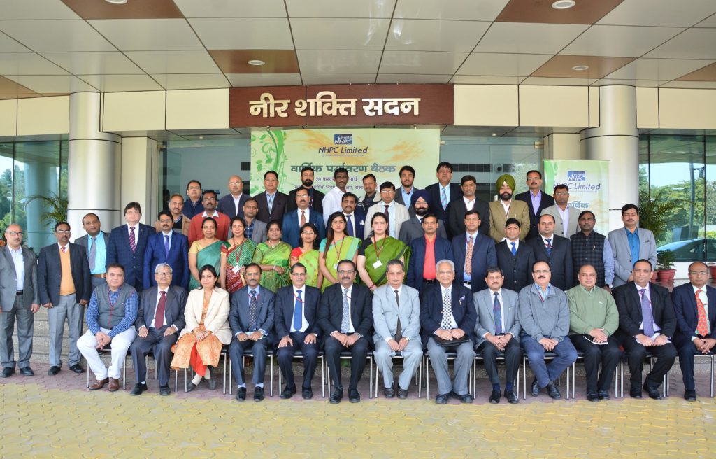
वार्षिक पर्यावरण बैठक 2018-19 (28 फरवरी – 1 मार्च, 2019) संपन्न – रिपोर्ट
पर्यावरण एवं विविधता प्रबंधन विभाग की दो दिवसीय (28 फरवरी से 1 मार्च, 2019) वार्षिक बैठक का उद्घाटन सत्र निगम मुख्यालय (नीर शक्ति सदन, पंचम तल सभागार) में सम्पन्न हुआ, इस अवसर पर माननीय अध्यक्ष एवं प्रबंध निदेशक महोदय श्री बलराज जोशी, निदेशक तकनीकी श्री जनार्दन चौधरी, कार्यपालक निदेशक (पर्यावरण एवं विविधता प्रबंधन) श्री ए के मिश्रा, कार्यपालक निदेशक (मानव संसाधन) श्री अविनाश कुमार, मुख्य महाप्रबंधक (मानव संसाधन) श्री संजय साराभाई, मुख्य महाप्रबंधक (सूचना प्रौद्योगिकी) श्रीमती सावित्री श्रीवास्तव सहित अनेक वरिष्ठ अधिकारी समुपस्थित थे। उद्घाटन सत्र में निगम मुख्यालय, विभिन्न परियोजनाओं/ पावरस्टेशनों में पदस्थ पर्यावरण क्षेत्र में कार्यरत अधिकारी ही नहीं अपितु एनएचडीसी एवं सीवीपीपी के पर्यावरण अधिकारियों ने भी प्रतिभागिता की।
उद्घाटन सत्र में अपना स्वागत उद्बोधन देते हुए श्री ए के मिश्रा, कार्यपालक निदेशक (पर्यावरण एवं विविधता प्रबंधन) ने पिछले एक वर्ष के दौरान निगम की पर्यावरण क्षेत्र में हासिल की गयी उपलब्धियों का विवरण प्रस्तुत किया। साथ ही सभी पर्यावरण अधिकारियों को सम्बोधित करते हुए उन्होंने कहा कि अपने तकनीकी ज्ञान का प्रयोग उन्हें निगम को नवीन पहल और दृष्टिकोण प्रदान करने के लिये करना चाहिये। निदेशक (तकनीकी) श्री जनार्दन चौधरी ने कहा कि समयपर्यंत पर्यावरण की नीतियों में जटिलता आती जा रही है ऐसे में निगम के पर्यावरण विभाग का दायित्व बढता जा रहा है। उन्होंने विभिन्न परियोजनाओं में संचालित पर्यावरण प्रवाह (ई-फ्लो), मत्स्य प्रबंधन, अपशिष्ट प्रबंधन जैसे पहलुओं पर भी प्रकाश डाला।
इस अवसर पर एनएचपीसी के ब्लॉग और उसके पर्यावरण पृष्ठ का अनावरण माननीय अध्यक्ष एवं प्रबंध निदेशक महोदय द्वारा किया गया। अनावरण से पूर्व मुख्य महाप्रबंधक (सूचना प्रौद्योगिकी) श्रीमती सावित्री श्रीवास्तव ने एनएचपीसी ब्लॉग के तकनीकी पहलुओं एवं उसकी आवश्यकता पर एक तकनीकी प्रस्तुतिकरण दिया।
कार्यक्रम में अपना अध्यक्षीय उद्बोधन प्रस्तुत करते हुए माननीय अध्यक्ष एवं प्रबन्ध निदेशक श्री बलराज जोशी ने प्रसन्नता जाहिर की कि पर्यावरण विभाग के ब्लॉग का आरम्भ किया जा रहा है। उन्होंने एक उदाहरण देते हुए यह अपेक्षा जतायी कि इस ब्लॉग के माध्यम से निगम के पर्यावरण प्रिय कार्यों के साथ ही समस्त उपलब्धियों का समुचित रूप से प्रचार प्रसार होगा एवं इस सोशल माध्यम से हम अपने कार्यों और विचारों को वैश्विक पटल पर सामने रख सकेंगे। उन्होंने प्रसन्नता जाहिर करते हुए कहा कि निगम के पास एक कुशल पर्यावरण की टीम है। पर्यावरण के क्षेत्र में प्राप्त उपलब्धियों के लिये उन्होंने विभाग की सराहना की एवं वार्षिक पर्यावरण बैठक को आयोजन के लिये शुभकामनायें प्रदान कीं। कार्यकम में धन्यवाद ज्ञापन महाप्रबंधक (पर्यावरण) डॉ. अनिल कुमार त्रिपाठी ने प्रस्तुत किया।
उद्घाटन सत्र के पश्चात विभिन्न तकनीकी सत्र दो दिवस तक सम्पन्न हुए जिसमे निम्नानुसार विभिन्न विषय विशेषज्ञों ने अपने विचार प्रस्तुत किये: –
| क्रम | विषय | व्याख्याता |
| 1. | Challenges of Disaster Risk Reduction for Development Planning in a Multi Hazard Ecosystem and the Way Forward | डॉ. आर के भण्डारी
आई आई रुडकी के विजिटिंग प्रोफेसर, ईराक में युनाईटेड नेशन हैबिटाट के पूर्व कार्यक्रम निदेशक होने के साथ साथ आपदा प्रबंधन पर जाने माने विशेषज्ञ |
| 2. | Policy Framework and Post Construction Monitoring in Hydropower Sector | डॉ. एस केरकेट्टा
निदेशक (आईए), पर्यावरण, वन एवं जलवायु परिवर्तन मंत्रालय |
| 3. | Sustainable Development Goals and their Significance in Hydropower Projects | श्री आनंद कुमार
यूएनडीपी के पूर्व राष्ट्रीय कार्यक्रम प्रबंधक तथा वर्तमान में आईपीई ग्लोबल के संयुक्त निदेशक |
| 4. | Use of Geo-informatics in Environmental Management and Social Impact Assessment in Hydropower Projects. | डॉ. पी के जोशी
प्राध्यापक, स्कूल ऑफ़ एन्वायरन्मेन्टल साईंस/ स्पेशल सेंटर फॉर डिजास्टर रिसर्च, जवाहर लाल नेहरू विश्व विद्यालय |
| 5. | Forest Clearance related issues in development of Hydropower Projects including FRA | श्री संदीप शर्मा
सीनियर एआईजी (एफ सी), पर्यावरण, वन एवं जलवायु परिवर्तन मंत्रालय |
| 6. | Climate Change – Challenges and Opportunity in Hydropower Sector | डॉ. एस सतपथी
पूर्व निदेशक, जलवायु परिवर्तन, पर्यावरण, वन एवं जलवायु परिवर्तन मंत्रालय |
तकनीकी सत्रों के पश्चात अंतिम सत्र में कार्यपालक निदेशक (पर्यावरण एवं विविधता प्रबंधन), श्री ए के मिश्रा की अध्यक्षता एवं महाप्रबंधक डॉ. अनिल कुमार त्रिपाठी की उपस्थिति में सभी निगम मुख्यालय/ परियोजनाओं/ पावर स्टेशनों/ एनएचडीसी एवं सीवीपीपी से आये पर्यावरण अधिकारियों ने अपने अनुभवों को साझा किया। कार्यक्रम के सभी सत्रों में मंच संचालन तथा अंतिम सत्र में धन्यवाद ज्ञापन उप-महाप्रबंधक (पर्यावरण) श्री गौरव कुमार ने किया।